IMAGES TAKEN NEAR TO
Balfour Street, LONDON, SE17 1PL
Introduction
This page details the photographs taken nearby to Balfour Street, SE17 1PL by members of the Geograph project.
The Geograph project started in 2005 with the aim of publishing, organising and preserving representative images for every square kilometre of Great Britain, Ireland and the Isle of Man.

There are currently over 7.5m images from over14,400 individuals and you can help contribute to the project by visiting https://www.geograph.org.uk
Image Map
Images are licensed for reuse under creativecommons.org/licenses/by-sa/2.0
Notes
- Clicking on the map will re-center to the selected point.
- The higher the marker number, the further away the image location is from the centre of the postcode.
Image Listing (210 Images Found)
Images are licensed for reuse under creativecommons.org/licenses/by-sa/2.0
Image
Details
Distance
1
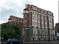
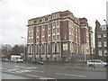
Driscoll House, 172 New Kent Road, SE1
This hotel was threatened with demolition so that a new housing development could be built on the site, but planning permission was refused. There is an application to have it given "listed" status. Follow these links to find out more http://en.wikipedia.org/wiki/Driscoll_House http://www.london-se1.co.uk/forum/read/1/40692 http://www.london-se1.co.uk/news/view/2056
Image: © Danny P Robinson
Taken: 11 May 2007
0.02 miles
2
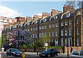
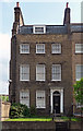
154-170 New Kent Road
A handsome late C18th terrace of nine houses, each of three storeys plus basement and attic in three bays (Image]), and possessing a decorative wooden doorcase (Image]). Grade II listed.
Image: © Stephen Richards
Taken: 6 May 2013
0.04 miles
3
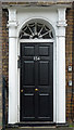
Detail of 154 New Kent Road
Doorcase with "attached columns with foliage capitals supporting entablature with medallions and dentil cornice" and radial fanlight.
Wider view: Image
Image: © Stephen Richards
Taken: 6 May 2013
0.05 miles
4
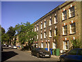
Henshaw Street, Walworth
An attractive street of 3-storey townhouses, that have outlived the later public housing of the nearby Heygate estate that was being demolished at this time.
Image: © Stephen Craven
Taken: 3 Jul 2014
0.05 miles
5
170 New Kent Road
One of the end houses in this good late C18th terrace (Image]). The doorcase (Image]) and rubbed brick flat arches to the windows are the only remotely decorative elements and yet the proportions and homely brick make for a satisfying facade.
Wider view: Image
Image: © Stephen Richards
Taken: 6 May 2013
0.05 miles
6
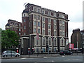
Driscoll House, New Kent Road
An imposing block in a revivalist style with a brick exterior but an early example of the use of Mouchel's iron and concrete construction method. Built as a women's hostel in 1911-13. Grade II listed.
Still a hostel, though not reserved for women, now run by Rest Up.
Image: © Stephen Richards
Taken: 6 May 2013
0.06 miles
7
Driscoll House, New Kent Road
Driscoll House is a Grade II listed building on the New Kent Road. It first opened as "Ada Lewis House" in 1913, offering accommodation for working women. Later it became a hotel, the Driscoll House Hotel, and more recently a student hostel. It closed in 2007, and despite local rumours that it would be demolished, was converted and sold to a developer. See also Image
(most of this information from Wikipedia: http://en.wikipedia.org/wiki/Driscoll_House )
Image: © Stephen Craven
Taken: 20 Mar 2010
0.06 miles
8
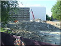
Heygate Estate demolition
The demolition of the Heygate Estate in inner south London is part of a £1.5billion project which will take a number of years to complete. This is the first part of the estate to be demolished, seen from the upper deck of a bus on Rodney Road.
Image: © Malc McDonald
Taken: 2 May 2011
0.06 miles
9
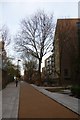
Victory Place
Looking along the pedestrianised Victory Place off Rodney Road.
Image: © DS Pugh
Taken: 9 Dec 2016
0.06 miles
10
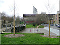
Ball games area, Victory Community Park, Walworth
The L-shaped park takes its name from Victory Place at its southeast corner. It adjoins Victory Primary School, Elba Place. In view here are a slab of the Heygate Estate, vacated and awaiting demolition, with the Strata Tower at Elephant and Castle beyond it. On the right is Munton Road.
Image: © Robin Stott
Taken: 9 Feb 2014
0.07 miles