IMAGES TAKEN NEAR TO
Worgan Street, LONDON, SE16 7WG
Introduction
This page details the photographs taken nearby to Worgan Street, SE16 7WG by members of the Geograph project.
The Geograph project started in 2005 with the aim of publishing, organising and preserving representative images for every square kilometre of Great Britain, Ireland and the Isle of Man.

There are currently over 7.5m images from over14,400 individuals and you can help contribute to the project by visiting https://www.geograph.org.uk
Image Map
Images are licensed for reuse under creativecommons.org/licenses/by-sa/2.0
Notes
- Clicking on the map will re-center to the selected point.
- The higher the marker number, the further away the image location is from the centre of the postcode.
Image Listing (267 Images Found)
Images are licensed for reuse under creativecommons.org/licenses/by-sa/2.0
Image
Details
Distance
1
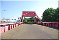
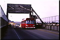
Lifting bridge, Redriff Road
The old lifting bridge which used to carry Redriff Road between the docks at Surrey Docks.
Image: © Malc McDonald
Taken: 10 May 2010
0.01 miles
3
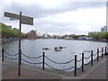
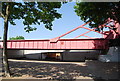
Greenland Dock
Greenland Dock regenerated.
Image: © Malc McDonald
Taken: 10 May 2010
0.02 miles
4

Rotherhithe: Redriff Road bascule bridge
A bascule bridge describes any bridge that has a counterweight that continuously balances the span throughout its entire upward swing. There can be double span bascule bridges such as Tower Bridge, or single span ones such as this. The word bascule is from the French term for a seesaw or balance.
Reading between the lines of information available on the internet this bridge had a comparatively short working life in this location. When the Greenland Dock was expanded westwards a short waterway cut was created to link it directly to the Canada Dock. Redriff Road passed over this cut by means of a bridge but not this one, which only appears to have been moved here from Deptford Creek in 1959. Probably with the building of the Surrey Quays shopping centre in the 1980s the cut was filled in and the alignment of Redriff Road moved slightly northwards to avoid the bridge, so it now stands out of use along the old route of the road.
The pedestrian subway under the newly-aligned Redriff Road leading to the Surrey Quays shopping centre from the former Greenland Dock can just be seen in the shadow under the bascule bridge to the left.
Image: © Nigel Cox
Taken: 18 Apr 2010
0.02 miles
5
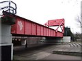
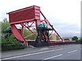
Lift bridge, Redriff Road, Rotherhithe
This bridge was originally built in 1949 and used at Deptfoed Creek before being moved here to what was Surrey Docks in 1959.
Image: © Chris Whippet
Taken: 9 Feb 2014
0.02 miles
8
Lifting bridge, Surrey Docks
This lifting bridge used to carry Redriff Road across the canal leading into Surrey Docks. Since the docks have closed down, there is no longer any need for the bridge to lift. In 1985, when this image was taken, the road still crossed the bridge. The road has since been diverted the lifting bridge. The lifting bridge is still in place today, part of the area's history, but no longer carries the road. The road has been diverted over a new fixed bridge alongside. For a more recent image of the bridge, have a look at Image
The warehouses in the background have also been demolished. The area which they occupied has beben redeveloped and is now a leisure park with restaurants, a bowling alley, cinema and bingo hall.
Image: © Malc McDonald
Taken: 31 Jul 1985
0.02 miles