IMAGES TAKEN NEAR TO
Bonding Yard Walk, LONDON, SE16 7UW
Introduction
This page details the photographs taken nearby to Bonding Yard Walk, SE16 7UW by members of the Geograph project.
The Geograph project started in 2005 with the aim of publishing, organising and preserving representative images for every square kilometre of Great Britain, Ireland and the Isle of Man.

There are currently over 7.5m images from over14,400 individuals and you can help contribute to the project by visiting https://www.geograph.org.uk
Image Map
Images are licensed for reuse under creativecommons.org/licenses/by-sa/2.0
Notes
- Clicking on the map will re-center to the selected point.
- The higher the marker number, the further away the image location is from the centre of the postcode.
Image Listing (417 Images Found)
Images are licensed for reuse under creativecommons.org/licenses/by-sa/2.0
Image
Details
Distance
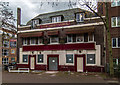
1
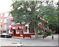
Ship York pub 15-16, Redriff Road, Rotherhithe, London, SE16
At the junction with Elgar Street and first recorded in 1809. With changes to the area its address is now 375, Rotherhithe Street. The pub has changed little since 1960's/1970's other than is it now very attractive both inside and out. The alley to the right used to be Redriff Road that led to Lower Road.
Image: © Chris Lordan
Taken: 19 Oct 2009
0.01 miles
2
The Ship pub (site of) Bedford Street, Rotherhithe, London, SE16
This stood from 1697 until 1747 in what is now called Gulliver Street and occupied a part of what is now the Redriff Estate. On the bend in the street can be seen the Ship & Whale pub - far right. Also in the late Bedford Street, believed between the late 1600's and early 1700's were 'The Chequers Alehouse' and the 'Trumbulls Galley'.
Image: © Chris Lordan
Taken: 9 Dec 2009
0.05 miles
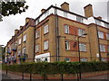
3
Greyhound pub (site of) 47 Russell Street, Rotherhithe, London SE16
The building on the left, Walker House of the Redriff Estate, was built over Russell Street, named in connection with the Duke of Bedford. The name was later changed to Derrick Street. There were two pubs in the street; this one was first recorded in 1862 and closed in 1894. It was previously the 'Vulcan Beer House'. At the end of the building shown and across Gulliver Street is the Ship & Whale pub; see Image
Image: © Chris Lordan
Taken: 11 Nov 2009
0.06 miles
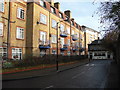
4
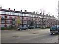
Redriff Estate (part), Rotherhithe, London, SE16
There are eight other blocks of varying sizes that complete the estate that is bounded by Rotherhithe Street, Elgar Street (Late York Street), Gulliver Street and Odessa Street (late Thames Street). Before the estate was built there was a Derrick Street (late Russel Street) between Elgar and Odessa Streets (about right of the image). Russel Street was named for the connection with the Duke of Bedfords family. Estate built 1931/40 as a community estate and comprised of a hall, gym, kitchen and hobby room with external facilities for football and cricket. Dignitaries from all over the UK attended the opening.
Image: © Chris Lordan
Taken: 23 Sep 2009
0.06 miles
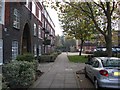
5
Prince of Prussia pub (site of) Derrick Street, Rotherhithe, London, SE16
This stood from 1860 to 1874 ending as a restaurant - not a cafe, as many other Rotherhithe pubs did. In the late 1930's the Redriff Estate was built over Derrick Street and in particular the building shown. This, since the 1980's has been called Walker House. See image 'Redriff Estate' http://www.geograph.org.uk/photo/1509041 that will explain the large open area.
Image: © Chris Lordan
Taken: 9 Dec 2009
0.06 miles
7
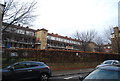
The Ship and Whale, Public House, Rotherhithe
Shepherd Neame Pub on Gulliver Street.
Had come to photograph the pub sign. No light! Another time!
Image: © David Anstiss
Taken: 15 Feb 2012
0.07 miles
9
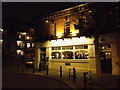
The Ship York
The Ship York public house. For a picture of the pub seen in happier days: Image
Image: © Peter McDermott
Taken: 6 Dec 2015
0.07 miles
10
Trinity Church School - Rotherhithe Street, SE16
Situated at the junction with Bryan Road, built in 1836 being arranged by the Rev Edward Blick - rector of St Mary's from 1835 until his death on 25-06-1867. The school closed in 1910 with the opening of Redriff Road school some 500 yards east in Rotherhithe Street. One wall bears the mark of the 1928 flood and is 3'-2" from ground level. Main floods of the area were in 1881, 1904, 1928 and 1953 - the 'main' meaning that boats had to be used to get essentials to marooned families. Currently contains a toddlers' group and a security firm. See second image http://www.geograph.org.uk/photo/1483023
Image: © Chris Lordan
Taken: 21 Jun 2005
0.07 miles