IMAGES TAKEN NEAR TO
Rotherhithe Street, LONDON, SE16 7RB
Introduction
This page details the photographs taken nearby to Rotherhithe Street, SE16 7RB by members of the Geograph project.
The Geograph project started in 2005 with the aim of publishing, organising and preserving representative images for every square kilometre of Great Britain, Ireland and the Isle of Man.

There are currently over 7.5m images from over14,400 individuals and you can help contribute to the project by visiting https://www.geograph.org.uk
Image Map (Loading...)


Getting Data...Please wait
Leaflet Map data © OpenStreetMap
Images are licensed for reuse under creativecommons.org/licenses/by-sa/2.0
Notes
- Clicking on the map will re-center to the selected point.
- The higher the marker number, the further away the image location is from the centre of the postcode.
Image Listing (568 Images Found)
Images are licensed for reuse under creativecommons.org/licenses/by-sa/2.0
Image
Details
Distance
1
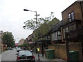
Ship public house (site of)
The pub stood at 194 Rotherhithe Street, London, SE16 junction with Neston Street from 1805 until 1961, although I believe it stopped trading before that. It would have stood where the red notice board can be seen on the right which is 200 Rotherhithe Street.
Image: © Chris Lordan
Taken: 31 Aug 2011
0.01 miles
3
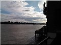
View along the Thames Path towards Bermondsey
Looking south-southwest.
Image: © Robert Lamb
Taken: 12 Jul 2014
0.02 miles
4
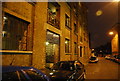
Ship pub (site of) 194, Rotherhithe Street, London, SE16
This stood at the junction with Neston Street from about 1805 until 1961. Neston Street ceased to exist in the early 1960's and was blocked off until the construction of the buildings shown in the late 1980's. Numbers shown are 206 and 208.
Image: © Chris Lordan
Taken: 4 Nov 2009
0.03 miles
5
View of Bermondsey from the riverside terrace of the Prospect of Whitby pub
Looking south-southwest.
Image: © Robert Lamb
Taken: 16 Sep 2012
0.03 miles
7
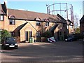
Blue Coat Boy pub (site of). 8, Dodds Place (late), Rotherhithe, London, SE16
Dodds Place was once at the east end and slightly north of Adam Street (now Brunel Road), between Canon Beck Road and Kinburn Street. The pub would have stood about the centre of the forecourt shown. It was first recorded in 1767 and destroyed by fire in 1827. In 1830 its licence was refused and it became 8 Dodds Place. It was also known as the 'Dial'.
Image: © Chris Lordan
Taken: 4 Nov 2009
0.03 miles
8
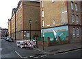
Watermans Arms pub (site of) 55, Swan Lane, Rotherhithe, London, SE16
This was a pub between 1852 and 1907 and thereafter a shop. It abutted Winchelsea House of the Swan Estate shown on the right. I remember it, 1960s, as a two storey building. I cannot answer my own query :- 2 storeys / abutting / window above mural. The pub protruded a little way past the bollard, as in the 1960s the road was very narrow. The shop disappeared in the early 1970s. Building in the centre is Rye House and in the background is the Adams Garden Estate.
Image: © Chris Lordan
Taken: 9 Dec 2009
0.04 miles
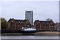
10
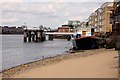
Houseboat and pier by the Thames
The pier is on Clarence Wharf.
Image: © Steve Daniels
Taken: 25 Jun 2012
0.04 miles