IMAGES TAKEN NEAR TO
Maritime Street, LONDON, SE16 7FW
Introduction
This page details the photographs taken nearby to Maritime Street, SE16 7FW by members of the Geograph project.
The Geograph project started in 2005 with the aim of publishing, organising and preserving representative images for every square kilometre of Great Britain, Ireland and the Isle of Man.

There are currently over 7.5m images from over14,400 individuals and you can help contribute to the project by visiting https://www.geograph.org.uk
Image Map
Images are licensed for reuse under creativecommons.org/licenses/by-sa/2.0
Notes
- Clicking on the map will re-center to the selected point.
- The higher the marker number, the further away the image location is from the centre of the postcode.
Image Listing (264 Images Found)
Images are licensed for reuse under creativecommons.org/licenses/by-sa/2.0
Image
Details
Distance
1
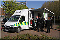
Time For a Brew
St. John Ambulance volunteers take the opportunity of a quick cuppa before looking after the runners taking part in the London Marathon.
Image: © Martin Addison
Taken: 22 Apr 2012
0.01 miles
2
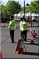
Policing The Marathon
Metropolitan Police Officers wait for the action to start on Surrey Quays Road. It looks like it was too early in the morning for the nearest officer - that's a big yawn!
Image: © Martin Addison
Taken: 22 Apr 2012
0.03 miles
3
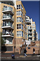
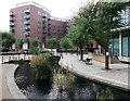
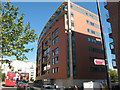
Apartment Blocks
Giverny House and Heligan House seen from Canada Street. The steps lead up to the water gardens that sit between the blocks in this small estate. In the foreground spectators begin to gather to watch the London Marathon.
Image: © Martin Addison
Taken: 22 Apr 2012
0.03 miles
5
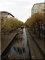
Albion Channel
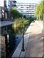
The Surrey Commercial Docks originated in 1696 and expanded over the next two centuries. Several of the docks were named after the origins of their customers' cargoes, hence Canada Dock, Quebec Pond, Norway Dock and Russia Dock. The Surrey Commercial Docks finally closed for lack of custom in 1969. About half of Canada Dock was infilled and the Surrey Quays Shopping Centre built on top of it; the remainder was converted into the present lake and wildlife refuge and renamed Canada Water. An ornamental canal, Albion Channel, was created through the site of the now filled-in Albion Dock to link Canada Water to Surrey Water, with the spoil used to create the nearby Stave Hill. This is looking along Albion Channel from its inlet by Canada Water. There are several bends and bridges along its course and it provides a pleasant outlook for the neighbouring flats.
Image: © Marathon
Taken: 14 Oct 2011
0.04 miles
6
Albion Channel, Surrey Quays (2)
As seen from near to Surrey Quays Road.
This was a canal linking Surrey Water (near the River Thames) with Canada Dock (now Canada Water) and Greenland Dock. Now remains as a water feature and walkway within the redeveloped area.
Image: © David Anstiss
Taken: 25 Sep 2011
0.05 miles
7
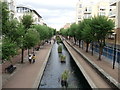
Albion Channel, Surrey Quays
As seen from Surrey Quays Road.
This was a canal linking Surrey Water (near the River Thames) with Canada Dock (now Canada Water) and Greenland Dock. Now remains as a water feature and walkway within the redeveloped area.
Image: © David Anstiss
Taken: 25 Sep 2011
0.05 miles
8
Path beside Albion Water
Formerly a commercial canal between docks, Albion Water has been landscaped into an amenity waterway.
Image: © Des Blenkinsopp
Taken: 22 May 2018
0.05 miles
9
New flats on Surrey Quays Road (2)
Unlike the block shown in Image, this block had been completed and possibly already occupied.
The two buses are both on route 47 (Shoreditch to Catford via London Bridge and Rotherhithe).
Image: © Stephen Craven
Taken: 22 May 2010
0.06 miles
10
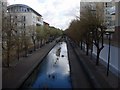
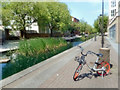
Waterway to Canada Water
Formerly to allow boats to reach Canada Water, now this area has been heavily redeveloped and the waterway retained as a landscape feature.
Image: © Hugh Venables
Taken: 13 Apr 2008
0.06 miles