IMAGES TAKEN NEAR TO
Fisher Close, LONDON, SE16 5AD
Introduction
This page details the photographs taken nearby to Fisher Close, SE16 5AD by members of the Geograph project.
The Geograph project started in 2005 with the aim of publishing, organising and preserving representative images for every square kilometre of Great Britain, Ireland and the Isle of Man.

There are currently over 7.5m images from over14,400 individuals and you can help contribute to the project by visiting https://www.geograph.org.uk
Image Map
Images are licensed for reuse under creativecommons.org/licenses/by-sa/2.0
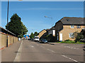
Notes
- Clicking on the map will re-center to the selected point.
- The higher the marker number, the further away the image location is from the centre of the postcode.
Image Listing (200 Images Found)
Images are licensed for reuse under creativecommons.org/licenses/by-sa/2.0
Image
Details
Distance
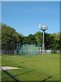
2
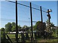
Disused golf driving range, Rotherhithe
The driving range is off Salter Road. This view is from a footpath between the range and the school playing fields. The high fence that spoils the view was obviously needed to keep golf balls from hitting users of the path. As of 2010 the range was derelict, with signs on the fence warning that unofficial use of the site was prohibited.
Image: © Stephen Craven
Taken: 23 May 2010
0.03 miles
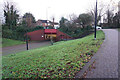
3
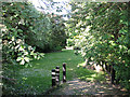
Small open space off Salter Road
This secluded green spot lies between Salter Road (or rather, an unnamed side road of it) and the footpath from Lagonda Mews to Russia Dock Woodland. I presume it is public space as there are no notices to the contrary.
Image: © Stephen Craven
Taken: 23 May 2010
0.04 miles
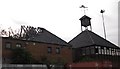
4
Disused club house, Rotherhithe
For a view of this derelict building from the opposite direction and something of its history, see Image
Image: © Stephen Craven
Taken: 23 May 2010
0.04 miles
5
Telecoms mast, Rotherhithe
The location of this mast - which looks like those used by mobile phone companies - is unusual in that it is neither on a hill, nor on top of a building, nor close to a main road. It is only a few hundred metres from the Thames so it might be intended to cover shipping.
Image: © Stephen Craven
Taken: 23 May 2010
0.06 miles
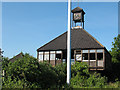
6
Ex Fisher Football club house, Salter Road, Rotherhithe, London, SE16
Built with the redevelopment of the Surrey Docks in the early 1980's. Later became a school for wayward children (so I understand) and gutted by fire prior to 2005. Fisher Club, that originated in Fair Street, Bermondsey, London, SE1, was founded by a Roman Catholic priest for boys of the area.
Image: © Chris Lordan
Taken: 23 Sep 2009
0.06 miles
7
Turf Zone "BeatsonWalk"
Beatson Walk, Rotherhite, London.
Image: © Ian S
Taken: 24 Dec 2022
0.07 miles
8
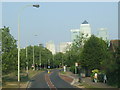
Salter Road, Rotherhithe
Salter Road was built in the 1980s, to improve access to the Rotherhithe peninsula. At the time, the peninsula was undergoing regeneration. Formerly the site of Surrey Docks, new housing was being built.
In the background are the towers of Canary Wharf.
Image: © Malc McDonald
Taken: 30 Apr 2011
0.08 miles
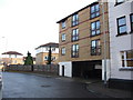
9
Lagado Mews, Rotherhithe
Typical of the modern (1990s-2000s) housing built in the former docklands on the Rotherhithe peninsula. The road is surfaced with brick paviours, a material that looks more pleasing visually than the usual bitumen macadam but is less rough than traditional setts.
Image: © Stephen Craven
Taken: 23 May 2010
0.08 miles
10
Boatswain and Call pub (site of) Rotherhithe Street, London, SE16
This stood from 1767 until 1810 at the junction with Charlotte Row, approximately where the right hand fir tree is shown. I'm not sure if this was once called the 'Charlotte Savage' as a pub with that name was in that immediate vicinity during the years shown. Just too difficult to even approximately isolate its location. Building on the far right is the ex Half Moon & Bulls Head pub.
Image: © Chris Lordan
Taken: 9 Dec 2009
0.09 miles