IMAGES TAKEN NEAR TO
Bermondsey Wall West, LONDON, SE16 4TN
Introduction
This page details the photographs taken nearby to Bermondsey Wall West, SE16 4TN by members of the Geograph project.
The Geograph project started in 2005 with the aim of publishing, organising and preserving representative images for every square kilometre of Great Britain, Ireland and the Isle of Man.

There are currently over 7.5m images from over14,400 individuals and you can help contribute to the project by visiting https://www.geograph.org.uk
Image Map
Images are licensed for reuse under creativecommons.org/licenses/by-sa/2.0
Notes
- Clicking on the map will re-center to the selected point.
- The higher the marker number, the further away the image location is from the centre of the postcode.
Image Listing (609 Images Found)
Images are licensed for reuse under creativecommons.org/licenses/by-sa/2.0
Image
Details
Distance
1
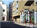
Bermondsey Wall West
Residential street in the renewed district of Docklands. Many old warehouses have been converted into apartments while many new apartment blocks have also been built like these at River View Heights.
Image: © Colin Smith
Taken: 2 Sep 2011
0.01 miles
2
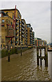
Bermondsey Wall West
A view of the riverside of the converted wharves. A solitary crane reminds us of the once busy scenes here where tea, coffee and spices were amongst the goods unloaded for a rapidly growing London. Congestion on the river, larger ships and finally containerisation all played a role in moving the traffic downstream to Tilbury and beyond.
Image: © Martin Addison
Taken: 22 Oct 2010
0.01 miles
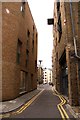
3
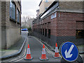
Flockton Street, Bermondsey
Surely one of the shortest and narrowest streets in London. 30m long and barely a car's width. The closure for roadworks cannot have inconvenienced anyone much.
Image: © Stephen Craven
Taken: 8 Mar 2015
0.02 miles
7
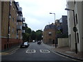
View down George Row from Bermondsey Wall East
Looking south-southwest.
Image: © Robert Lamb
Taken: 20 Aug 2016
0.03 miles
8
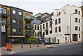
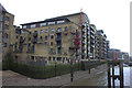
Providence Square
Ironically, a square apartment block on George Row. The adjacent cream building appears to be an original industrial building converted to housing.
Image: © Martin Addison
Taken: 22 Oct 2010
0.03 miles
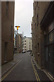
9
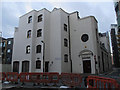
St Saviour's House, Bermondsey Wall West
The only online reference I could find to this building, other than property agents' websites, was the deposit of document with the Museum of London in 2010 by Pre Construct Archaeology Ltd, reference BYA00.
Image: © Stephen Craven
Taken: 8 Mar 2015
0.03 miles
10
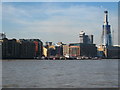
Waterfront buildings in Bermondsey
On the Upper Pool of the Port of London. Although little port trade is carried out now, the piers in the picture are mostly occupied by barges and other commercial rivercraft. On the right, under construction, is 'The Shard', designed by Renzo Piano and due, when completed in 2012, to be the tallest building in the European Union at 1017 feet (310m).
Image: © Rod Allday
Taken: 19 Mar 2011
0.03 miles