IMAGES TAKEN NEAR TO
Brunel Road, LONDON, SE16 4LE
Introduction
This page details the photographs taken nearby to Brunel Road, SE16 4LE by members of the Geograph project.
The Geograph project started in 2005 with the aim of publishing, organising and preserving representative images for every square kilometre of Great Britain, Ireland and the Isle of Man.

There are currently over 7.5m images from over14,400 individuals and you can help contribute to the project by visiting https://www.geograph.org.uk
Image Map
Images are licensed for reuse under creativecommons.org/licenses/by-sa/2.0
Notes
- Clicking on the map will re-center to the selected point.
- The higher the marker number, the further away the image location is from the centre of the postcode.
Image Listing (633 Images Found)
Images are licensed for reuse under creativecommons.org/licenses/by-sa/2.0
Image
Details
Distance
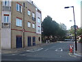
1
Junction of Swan Road with Brunel Road, Rotherhithe
Image: © Ruth Sharville
Taken: 21 Feb 2011
0.00 miles
4
Rotherhithe Tunnels
Encased road and entrance to Fitzmaurice's Rotherhithe Tunnel as seen from the extension of Brunel's tunnel ie Rotherhithe underground station.
Image: © Chris Lordan
Taken: 5 Oct 2007
0.01 miles
5
Prince Regent public house (site of)
Site of that was the east side of Clarence Street, Rotherhithe,SE16 (now Canon Beck Road), from 1814 to 1821. After looking at many maps I have taken an 'educated guess' and placed it between Brunel Road (where I am standing to take the image) down to the old Albion Dock as per image.
Image: © Chris Lordan
Taken: 24 Jul 2011
0.01 miles
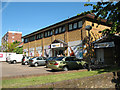
6
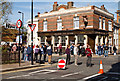
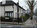
Adam and Eve, Brunel Road
An old East London Brewery house (The Wenlock Brewery Co of Wenlock Road in Shoreditch) which was built in 1913. The dock trade may have gone but there is a large residential community to serve in Rotherhithe. Spectators have gathered to watch the London Marathon passing through.
Image: © Martin Addison
Taken: 22 Apr 2012
0.02 miles
7
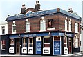
Wenlock Brewery's Adam & Eve
Recent pictures of this corner pub show that the Wenlock Brewery panels at the top of the pub have been painted over.
This was how it looked around 25 years ago.
Wenlock Brewery was in Wenlock Road, Shoreditch, and was bought out by Bass brewery in 1961.
From a print. Date approximate.
Image: © Des Blenkinsopp
Taken: Unknown
0.02 miles
8
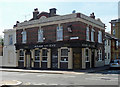
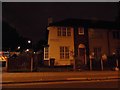
Adam and Eve, Brunel Road
Brick pub on the corner of Swan Road. Above the cornice are well-preserved signs reading, "1913 / The Wenlock Brewery Co Ltd".
A view approximately twenty-five years earlier: Image
Image: © Stephen Richards
Taken: 26 May 2013
0.02 miles
9
NISA local, Rotherhithe
Signs on this convenience store suggest it was newly opened in 2010. Presumably it competes for trade with nearby Londis Image It lies between Brunel Road (this side) and Albion Street; the Rotherhithe Road Tunnel runs under the car park.
Image: © Stephen Craven
Taken: 22 May 2010
0.03 miles
10
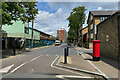
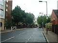
Northeast on Albion Street, Rotherhithe
The Overground station is a few steps to the northeast via Old Railway Walk, signposted left of centre. The postbox ID is SE16 10. The block of flats ahead is Pine House, one of several blocks named after trees. What would developers and councils do without trees to name so many blocks after?
Photo number 7784225.
Image: © Robin Stott
Taken: 27 May 2024
0.04 miles