IMAGES TAKEN NEAR TO
Cope Street, LONDON, SE16 2UL
Introduction
This page details the photographs taken nearby to Cope Street, SE16 2UL by members of the Geograph project.
The Geograph project started in 2005 with the aim of publishing, organising and preserving representative images for every square kilometre of Great Britain, Ireland and the Isle of Man.

There are currently over 7.5m images from over14,400 individuals and you can help contribute to the project by visiting https://www.geograph.org.uk
Image Map
Images are licensed for reuse under creativecommons.org/licenses/by-sa/2.0
Notes
- Clicking on the map will re-center to the selected point.
- The higher the marker number, the further away the image location is from the centre of the postcode.
Image Listing (224 Images Found)
Images are licensed for reuse under creativecommons.org/licenses/by-sa/2.0
Image
Details
Distance
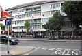
1
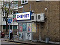
Cope Street, Rotherhithe
Showing the junction with Lower Road in the Surrey Quays area. The use of the traditional 'chemist' for a pharmacy is generally dying out, but evidently not here.
Image: © Stephen McKay
Taken: 6 Nov 2015
0.02 miles
2
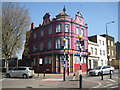
Rotherhithe: The former Crystal Tavern
A fine example of a Victorian public house, there is a date of 1895 in the pediment on the right hand side. It is now occupied by a Christian evangelistic organization, Arise and Shine http://www.arise-shine.org/ and is known as the London Outreach Center (their spelling not mine). It is on the corner of Rotherhithe Old Road, to the left, and Rotherhithe New Road to the right.
Image: © Nigel Cox
Taken: 18 Apr 2010
0.03 miles
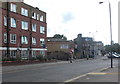
5
Warrior public house (site of)
Site of what was 209 Lower Road, Rotherhithe, SE16 junction with Maynard Road and opposite Cope Street. Opened in 1862 as the 'Manor Beer House' and closed with the building of the Osprey Estate in the early 1970s. Warrior II (now Surrey Docks pub) was built about 50 yards to the left at the junction with Redriff Road. Image shows Tawny Way of the Osprey Estate.
Image: © Chris Lordan
Taken: 17 Aug 2011
0.03 miles
6
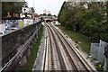
East London Line
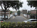
A view of the recently revamped tracks just south of Surrey Quays station, taken from Cope Street.
Image: © Martin Addison
Taken: 22 Oct 2010
0.03 miles
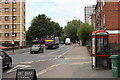
7
Woodman public house (site of)
Site of Woodman public house, a map dated 1868 showed it on the north side of Rotherhithe New Road close to the junction with Lower Road. Above is 'today's' view.
Image: © Chris Lordan
Taken: 24 Jul 2011
0.03 miles
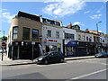
9

Crystal Tavern pub (ex). 32 Rotherhithe New Road, London, SE16
At the junction with Rotherhithe Old Road, first recorded in 1852 and as it has 1895 on the roof I assume this is the second building. It is now some type of church and I do not know when it stopped trading as a pub but the owners seem to be backing it both ways as the pub sign together with the Courage Cockerel are still displayed on the right of the building.
Image: © Chris Lordan
Taken: 19 Oct 2009
0.04 miles
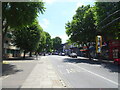
10
Little Wonder public house - site of
It was number 1 Cross Street (now Cope Street) from 1868 to an unknown date but believed to have been short lived. It was on a corner at the junction with Rotherhithe Old Road but I do not know which one, so have shown both. Believe it was also known as, or previously called, the "Royal William".
Image: © Chris Lordan
Taken: 26 Jun 2011
0.04 miles