IMAGES TAKEN NEAR TO
Silwood Street, LONDON, SE16 2SW
Introduction
This page details the photographs taken nearby to Silwood Street, SE16 2SW by members of the Geograph project.
The Geograph project started in 2005 with the aim of publishing, organising and preserving representative images for every square kilometre of Great Britain, Ireland and the Isle of Man.

There are currently over 7.5m images from over14,400 individuals and you can help contribute to the project by visiting https://www.geograph.org.uk
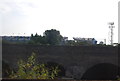
Image Map
Images are licensed for reuse under creativecommons.org/licenses/by-sa/2.0
Notes
- Clicking on the map will re-center to the selected point.
- The higher the marker number, the further away the image location is from the centre of the postcode.
Image Listing (222 Images Found)
Images are licensed for reuse under creativecommons.org/licenses/by-sa/2.0
Image
Details
Distance
1
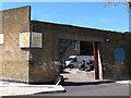
Lions Tyres, Silwood Street
One of many businesses, mostly in the field of vehicle maintenance, occupying arches underneath the London Bridge to Greenwich railway viaduct.
Image: © Stephen Craven
Taken: 2 May 2013
0.03 miles
2
Bolina Road, blocked off
Bolina Road was closed permanently at its northern end from 18 January 2013 for construction of new railway lines as part of the Thameslink project. The 8ft 9in height restriction shown applied to the lowest of the viaducts crossing the road, as shown in Image For the far end of the closed section, see Image
Image: © Stephen Craven
Taken: 2 May 2013
0.03 miles
4
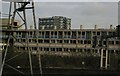
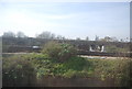
Trackside, Bermondsey: derelict flats
Part of the Silwood Estate.
Image: © Christopher Hilton
Taken: 14 Dec 2010
0.05 miles
5
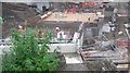
Work on the Bermondsey Diveunder
Looking down on construction works which will eventually allow the Charing Cross lines to 'dive under' the Thameslink lines into London Bridge. For an explanation, see [http://www.londonreconnections.com/2015/bermondsey-diveunder/]
Image: © David Martin
Taken: 23 Jun 2016
0.05 miles
7
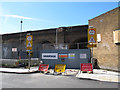
Cleared site, Silwood Street
Various small engineering businesses and the like that used to operate from railway arches on Silwood Street, had been removed to make way for work on the Bermondsey Diveunder (part of the Thameslink project to increase capacity through London Bridge). See also Image nearby.
Image: © Stephen Craven
Taken: 16 Apr 2014
0.06 miles
8

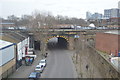
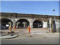
Bolina Road bridges (1)
Bolina Road is a narrow minor road, used mainly by commercial vehicles going to/from local industrial sites, that passes under five railway bridges, three of them shown on this picture. The lowest of them, in the distance on this photo, is disused (it carried the former Bricklayers Arms freight line). The others all lead towards London Bridge.
Update: Bolina Road was to be closed permanently from 18 January 2013 for construction of new railway lines as part of the Thameslink project.
Image: © Stephen Craven
Taken: 22 Oct 2008
0.06 miles
10
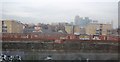
Railway arches, Deptford
The Den beyond.
Image: © N Chadwick
Taken: 21 Aug 2013
0.07 miles