IMAGES TAKEN NEAR TO
Crewys Road, LONDON, SE15 2BJ
Introduction
This page details the photographs taken nearby to Crewys Road, SE15 2BJ by members of the Geograph project.
The Geograph project started in 2005 with the aim of publishing, organising and preserving representative images for every square kilometre of Great Britain, Ireland and the Isle of Man.

There are currently over 7.5m images from over14,400 individuals and you can help contribute to the project by visiting https://www.geograph.org.uk
Image Map
Images are licensed for reuse under creativecommons.org/licenses/by-sa/2.0
Notes
- Clicking on the map will re-center to the selected point.
- The higher the marker number, the further away the image location is from the centre of the postcode.
Image Listing (68 Images Found)
Images are licensed for reuse under creativecommons.org/licenses/by-sa/2.0
Image
Details
Distance
1
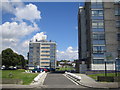
Peckham: Brayards Estate, SE15
These are 1960s built small tower blocks on the Brayards Estate managed by Southwark Council. The distant one is Walkynscroft and the near one is Ryegates. The view is taken from Caulfield Road.
Image: © Nigel Cox
Taken: 18 Jul 2007
0.05 miles
2
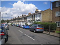
Peckham: Kirkwood Road, SE15
Victorian terraced houses typical of the area.
Image: © Nigel Cox
Taken: 18 Jul 2007
0.11 miles
3
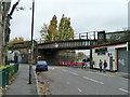
Railway bridge CAT 432 over Brayards Road
Looking from Gordon Road, which continues on the other side of the bridge, as does Brayards Road. The highway people have plated the road under the bridge as Brayards Road, whilst the railway people call the bridge Gordon Road on their plate. Pre-railway and shortly post-railway maps suggest Gordon Road is the more senior as a through route, which is probably why the railway used the name.
Image: © Robin Webster
Taken: 30 Oct 2011
0.13 miles
4
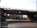
Railway bridge over Brayard's Road
The bridge is at the junction of Brayard's Road and Gordon Road.
Brayard's Road leads straight on from Hollydale Road towards Copeland Road.
Gordon Road leads right towards to Consort Road, or left towards Evelina Road.
The bridge carries the line between Nunhead and Peckham Rye.
Image: © David Anstiss
Taken: 25 Sep 2011
0.13 miles
5
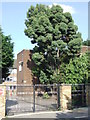
St Thomas the Apostle College, SE15
Entrance gate to St Thomas the Apostle College, on Hollydale Road, SE15.
Image: © Malc McDonald
Taken: 27 Jun 2010
0.16 miles
6
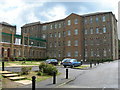
Nazareth Gardens, SE15
This site has quite a history. It was the site of a convent until the mid 19th century, then for over 120 years it was a hostel for homeless people. Now it has been converted into flats.
This link tells a little more about "The Camberwell Spike" as it was once known. It is not in Camberwell, though, and there is uncertainty about how the term "Spike" for a hostel originated.
http://briandeer.com/social/london-homeless.htm
Image: © Danny P Robinson
Taken: 19 Aug 2006
0.17 miles
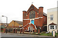
7
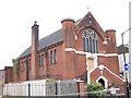
Christ Miracle Gospel Ministries, Consort Road
There are several African-majority churches in Peckham with peculiar (in the old sense) names of which this is just one. The church was originally St Paul's (Anglican) from 1907-1982 but never had its own parish.
Image: © Stephen Craven
Taken: 26 Jul 2005
0.17 miles
8
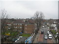
Evelina Road, Nunhead
Looking towards New Cross. This was taken from the railway bridge near Nunhead Station. The office buildings in the far distance, middle of shot, are at Canary Wharf.
Image: © Danny P Robinson
Taken: 11 Apr 2006
0.17 miles
10
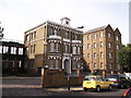
Nazareth Gardens, Peckham Rye
This site on Gordon Road, has quite a history. It was the site of a convent until the mid 19th century, then for over 120 years it was a hostel for homeless people. Now it has been converted into flats.
See also Image
Image: © David Anstiss
Taken: 25 Sep 2011
0.17 miles