IMAGES TAKEN NEAR TO
John Williams Close, LONDON, SE14 5XB
Introduction
This page details the photographs taken nearby to John Williams Close, SE14 5XB by members of the Geograph project.
The Geograph project started in 2005 with the aim of publishing, organising and preserving representative images for every square kilometre of Great Britain, Ireland and the Isle of Man.

There are currently over 7.5m images from over14,400 individuals and you can help contribute to the project by visiting https://www.geograph.org.uk
Image Map
Images are licensed for reuse under creativecommons.org/licenses/by-sa/2.0
Notes
- Clicking on the map will re-center to the selected point.
- The higher the marker number, the further away the image location is from the centre of the postcode.
Image Listing (77 Images Found)
Images are licensed for reuse under creativecommons.org/licenses/by-sa/2.0
Image
Details
Distance
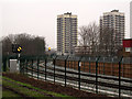
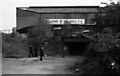
1
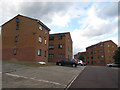
New housing, John Williams Close
The nearer block, Thompson House, is roughly on the line of a railway shown on old maps that linked sidings at Deptford Wharf on the Thames to the South London Loop line through Peckham.
Image: © Stephen Craven
Taken: 22 Jul 2015
0.01 miles
2
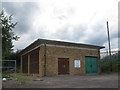
National Grid cooling station, John Williams Close
One of 14 surface cooling station buildings at 1-mile intervals serving the National Grid underground cable tunnel between Bexley Image and Wimbledon. To allow these cables to carry more current, there are cooling pipes adjacent to the cables, carrying water pumped from these cooling stations. The shafts, tunnels and cooling stations were originally constructed in the 1960’s and are the route for the main 275kV cables supplying South London. They were refurbished in 2005.
[Sources: http://www.skanska.co.uk/cdn-1cd94af82cd9070/Global/Sevices/Civils/Document/Wimbledon-Tunnels-Project-Sheet.pdf and http://www.alpine-components.co.uk/case-studies-feedback/national-grid/john-howlett/ ]
The facility is roughly on the line of a railway shown on old maps that linked sidings at Deptford Wharf on the Thames to the South London Loop line through Peckham.
Image: © Stephen Craven
Taken: 22 Jul 2015
0.02 miles
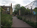
3
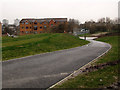
New path through Bridge House Meadows (4)
The path descends at its northern end to the subway under Hornshay Street. The housing block in the photo is Thompson House. A bicycle lies abandoned on the grass.
Image: © Stephen Craven
Taken: 18 Jan 2013
0.03 miles
4
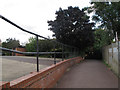
Footpath between Avonley Road and John Williams Close (1)
Looking east towards the John Williams Close end. This section of the path roughly follows a railway line shown on old maps that linked the main line at New Cross Gate to the South London Loop line through Peckham.
Image: © Stephen Craven
Taken: 22 Jul 2015
0.03 miles
5
Signals on the Peckham link line
The four aspect signal (at double yellow in this view) protects the junction of the link line from Surrey Quays with the South London line through Peckham. because of the curving track, there is an advance repeater, which is showing a diagonal (caution) aspect.
Image: © Stephen Craven
Taken: 18 Jan 2013
0.04 miles
6
Footpath between Avonley Road and John Williams Close (1)
Looking south towards the houses on Avonley Road.
Image: © Stephen Craven
Taken: 22 Jul 2015
0.04 miles
7
Underpass from Bridge House Meadows to Hornshay St
The railway is the London Overground between Queens Road Peckham and Surrey Quays.
Image: © Robert Eva
Taken: 4 Jan 2020
0.05 miles
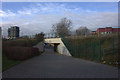
8
Hornshay Street subway
A new subway under the railway embankment links Hornshay Street to the west with Bridge House Meadows to the east.
The tower blocks in the distance are (I think) Grasmere Point Image and Ambleside Point.
Image: © Stephen Craven
Taken: 18 Jan 2013
0.05 miles
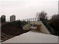
10
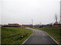
New path through Bridge House Meadows (3)
The level section of path alongside the new railway line (right). Bridge House Meadows is the open space to the left.
Image: © Stephen Craven
Taken: 18 Jan 2013
0.08 miles