IMAGES TAKEN NEAR TO
Shad Thames, LONDON, SE1 2NW
Introduction
This page details the photographs taken nearby to Shad Thames, SE1 2NW by members of the Geograph project.
The Geograph project started in 2005 with the aim of publishing, organising and preserving representative images for every square kilometre of Great Britain, Ireland and the Isle of Man.

There are currently over 7.5m images from over14,400 individuals and you can help contribute to the project by visiting https://www.geograph.org.uk
Image Map
Images are licensed for reuse under creativecommons.org/licenses/by-sa/2.0
Notes
- Clicking on the map will re-center to the selected point.
- The higher the marker number, the further away the image location is from the centre of the postcode.
Image Listing (831 Images Found)
Images are licensed for reuse under creativecommons.org/licenses/by-sa/2.0
Image
Details
Distance
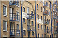
1
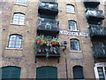
Balcony in Shad Thames
Someone in Bermondsey is making the most of their balcony here.
Image: © Marathon
Taken: 10 Dec 2018
0.01 miles
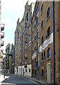
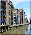
2
St Andrew's and St George's Wharfs, Shad Thames
Former tea, coffee and spice warehouses now in residential use.
Image: © John Sutton
Taken: 2 Nov 2019
0.01 miles
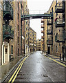
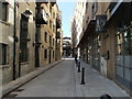
3
Shad Thames (2)
Despite late C20th dilutions, the street retains a sense of its industrial past with many surviving warehouses, now mostly converted to shops/restaurants and flats above. Some wrought-iron walkways survive too.
On the right a series of warehouses dating from the second half of the C19th (Image]). All grade II listed.
Image: © Stephen Richards
Taken: 26 May 2013
0.02 miles
4
Converted Warehouses along Shad Thames
In Victorian times, Shad Thames included the largest warehouse complex in London. Completed in 1873, the warehouses housed huge quantities of tea, coffee, spices and other commodities, which were unloaded and loaded onto river boats.
Lots more info on https://en.wikipedia.org/wiki/Shad_Thames although theories on where the name Shad Thames came from are a bit vague.
Image: © Des Blenkinsopp
Taken: 21 Feb 2018
0.02 miles
5
Shad Thames
Shad Thames is an historic riverside street next to Tower Bridge in Bermondsey, London
Image: © PAUL FARMER
Taken: 11 Sep 2011
0.02 miles
6
Shuter's Wharf & St.George's Wharf
Apartments in converted wharf buildings at St.Saviour's Dock http://www.geograph.org.uk/photo/2836479
Image: © Richard Croft
Taken: 16 Aug 2011
0.03 miles
7
St Saviour's Dock, Bermondsey
A tidal dock, now disused, the mouth of the River Neckinger, which otherwise is culverted underground.
Image: © Robin Webster
Taken: 6 Apr 2019
0.03 miles
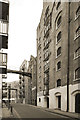
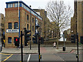
8
Shad Thames
Looking northeast from the junction with Queen Elizabeth Street. On the right are St. Saviours and St. Andrews Wharves, both now converted to offices and apartments. St. Saviours Wharf takes its name from the dock behind the line of wharves. The Wharves originally housed imported tea, coffee and spices.
Image: © Martin Addison
Taken: 22 Oct 2010
0.03 miles
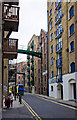
9
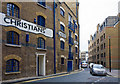
Shad Thames
Seen at the junction with Queen Elizabeth Street, with Christians and Shuter's Wharves to the left. At the end of the street is Jamaica Road. The wharves, no longer used for the importation of tea, coffee and spices, have been converted to offices and apartments
Image: © Martin Addison
Taken: 22 Oct 2010
0.03 miles
10
St Saviour's Dock
Lined with a series of warehouses dating from the second half of the C19th. All grade II listed.
The subterranean River Neckinger emerges into the Thames here.
Image: © Stephen Richards
Taken: 26 May 2013
0.03 miles