IMAGES TAKEN NEAR TO
Hennoyadd Road, SWANSEA, SA9 1US
Introduction
This page details the photographs taken nearby to Hennoyadd Road, SA9 1US by members of the Geograph project.
The Geograph project started in 2005 with the aim of publishing, organising and preserving representative images for every square kilometre of Great Britain, Ireland and the Isle of Man.

There are currently over 7.5m images from over14,400 individuals and you can help contribute to the project by visiting https://www.geograph.org.uk
Image Map
Images are licensed for reuse under creativecommons.org/licenses/by-sa/2.0
Notes
- Clicking on the map will re-center to the selected point.
- The higher the marker number, the further away the image location is from the centre of the postcode.
Image Listing (31 Images Found)
Images are licensed for reuse under creativecommons.org/licenses/by-sa/2.0
Image
Details
Distance
1
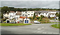
Houses near the western edge of Abercrave
Viewed across Heol Rheolau (the A4067).
Image: © Jaggery
Taken: 29 Aug 2011
0.02 miles
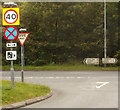
2
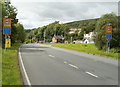
Eastern boundary of Cae'r-Lan
The A4067 from Abercrave reaches Cae'r-Lan.
The speed limits reduces from the National Speed Limit to 40mph.
Image: © Jaggery
Taken: 29 Aug 2011
0.03 miles
3
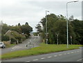
Across a grass triangle towards the centre of Abercrave
A view from the A4067 towards Heol Tawe, the main road through Abercrave.
The sign shows the Welsh language spelling Abercraf.
Image: © Jaggery
Taken: 29 Aug 2011
0.04 miles
4
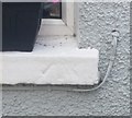
Ordnance Survey Rivet
This OS rivet can be found on the window sill of Glan-y-Nant. It marks a point 131.772m above mean sea level.
Image: © Adrian Dust
Taken: 10 Jul 2020
0.04 miles
5
Incorrect distance shown on road sign, Abercrave
The distance shown to Swansea is 8 miles, whereas the actual distance is nearer 16 miles.
The A4067 to Swansea goes through Ystradgynlais, which is about 13 miles NE
of central Swansea and 3 miles from this spot (as shown on the sign).
Turn left for Sennybridge (14 miles) or Brecon (24 miles).
Image: © Jaggery
Taken: 29 Aug 2011
0.05 miles
6
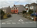
Hennoyadd houses, Abercrave
The street name sign shows Hennoyadd leading to Trefleming.
Image: © Jaggery
Taken: 29 Aug 2011
0.05 miles
7
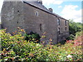
Hen Neuadd
Adeiladwyd y ty cyntaf yn ystod y 15g ac fe'i hailgodwyd yn bennaf yn ystod y 17g. Gweddnewidiwyd yr anhedd-dy yn y 19g ac fe'i hadnewidiwyd yn 1986.
With early C15 origins the house was largely rebuilt during the 17th century. Altered during the 19th century the property was restored in 1986.
Image: © Alan Richards
Taken: 20 Jul 2020
0.06 miles
8
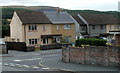
Henneuadd, Abercrave
Houses at the eastern end of the residential street named Henneuadd.
Image: © Jaggery
Taken: 29 Aug 2011
0.07 miles
9
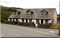
Barn Cottages, Abercrave
A row of three low-roofed houses in Hennoyadd, Abercrave.
Image: © Jaggery
Taken: 29 Aug 2011
0.08 miles
10
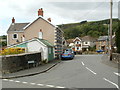
Southern end of Hennoyadd Road, Abercrave
Viewed from Heol Tawe. All references I've consulted show the street as Hennoyadd Road whereas the name sign by the wall shows only Hennoyadd.
Hennoyadd is an Anglicised form of the Welsh Henneuadd which is the name of a nearby street.
Image: © Jaggery
Taken: 29 Aug 2011
0.09 miles