IMAGES TAKEN NEAR TO
Ropeyard Close, FISHGUARD, SA65 9BH
Introduction
This page details the photographs taken nearby to Ropeyard Close, SA65 9BH by members of the Geograph project.
The Geograph project started in 2005 with the aim of publishing, organising and preserving representative images for every square kilometre of Great Britain, Ireland and the Isle of Man.

There are currently over 7.5m images from over14,400 individuals and you can help contribute to the project by visiting https://www.geograph.org.uk
Image Map
Images are licensed for reuse under creativecommons.org/licenses/by-sa/2.0
Notes
- Clicking on the map will re-center to the selected point.
- The higher the marker number, the further away the image location is from the centre of the postcode.
Image Listing (88 Images Found)
Images are licensed for reuse under creativecommons.org/licenses/by-sa/2.0
Image
Details
Distance
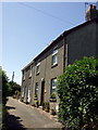
1
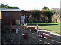
Ropeyard barn conversion
Two cottages have been created from this old barn in the part of the town still called Ropeyard: a remnant of the past in an otherwise modern residential area.
Image: © Natasha Ceridwen de Chroustchoff
Taken: 24 Jun 2010
0.03 miles
2
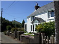
Foundry House
The name is the only clue that there must once have been a foundry here, in Ropeyard Lane.
Image: © Natasha Ceridwen de Chroustchoff
Taken: 24 Jun 2010
0.06 miles
3
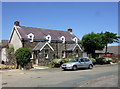
Ropeyard Lane
These houses are no doubt contemporary with the rope making industry in Fishguard but the surrounding area was developed in the second half of the C20 as a residential estate of neat bungalows in quiet culs de sac.
Image: © Natasha Ceridwen de Chroustchoff
Taken: 24 Jun 2010
0.06 miles
4
Gnome, sweet gnome
Signs of a serious gnome infestation in this tidy little garden!
Image: © Natasha Ceridwen de Chroustchoff
Taken: 11 Feb 2009
0.08 miles
5
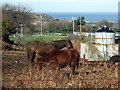
Horses and magpies
Slim pickings for the horses in this grassless paddock, although they had hay supplied. The magpies (left) seemed to be finding plenty to peck at however.
Below lie Fishguard High School's pitches bounded by the new access road from West Street. The red funnel of the ferry to Rosslare is visible in the harbour.
Image: © Natasha Ceridwen de Chroustchoff
Taken: 11 Feb 2009
0.09 miles
6
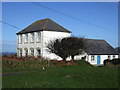
Former intermediate school, Fishguard
The old school was turned into Fishguard community education centre and is accessed from the back, the result being that one rarely sees its frontage.
An old postcard view shows that it was once an imposing sight perched up above the town before present-day infill housing.
It was replaced with the new junior school in 2011.
Image: © Natasha Ceridwen de Chroustchoff
Taken: 11 Feb 2009
0.10 miles
7
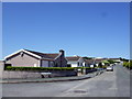
Clos-y-Bigney
Modern residential development on the western edge of Fishguard, on the slope of Bigney Hill.
Image: © Natasha Ceridwen de Chroustchoff
Taken: 24 Jun 2010
0.10 miles
8
Bigney Hill: peaceful now
This is the hill around which, in February 1797, the cobbler Jemima Nicholas is said to have marched her troop of Welsh women, dressed in their red shawls and black hats. Legend has it that the invading French force took them for an endless stream of British soldiers and, feeling hopelessly outnumbered, laid down their arms. This story may or may not be apocryphal.
Image: © Natasha Ceridwen de Chroustchoff
Taken: 8 Nov 2006
0.10 miles
9

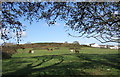
Y Bigney, from the north
The same hill can be seen from the opposite direction in Image It is an area of rough grazing with a substantial coverage of gorse.
The conical stone standing in the field does not possess any archaeological significance.
Image: © Natasha Ceridwen de Chroustchoff
Taken: 11 Feb 2009
0.10 miles