IMAGES TAKEN NEAR TO
Station Road, SWANSEA, SA4 6TR
Introduction
This page details the photographs taken nearby to Station Road, SA4 6TR by members of the Geograph project.
The Geograph project started in 2005 with the aim of publishing, organising and preserving representative images for every square kilometre of Great Britain, Ireland and the Isle of Man.

There are currently over 7.5m images from over14,400 individuals and you can help contribute to the project by visiting https://www.geograph.org.uk
Image Map (Loading...)


Getting Data...Please wait
Leaflet Map data © OpenStreetMap
Images are licensed for reuse under creativecommons.org/licenses/by-sa/2.0
Notes
- Clicking on the map will re-center to the selected point.
- The higher the marker number, the further away the image location is from the centre of the postcode.
Image Listing (89 Images Found)
Images are licensed for reuse under creativecommons.org/licenses/by-sa/2.0
Image
Details
Distance
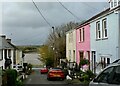
2
Station Road, Loughor
Viewed past the corner of Dock Street. This used to be the way to Loughor railway station which closed in 1960.
Image: © Jaggery
Taken: 25 Mar 2016
0.02 miles
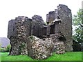
3
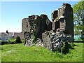
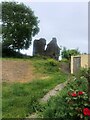
Loughor Castle
Today, Loughor Castle is not much more than a ruin; it is located in a strategic position near the crossing point of the River Loughor. Even today the A484 and railway crosses the river here. The castle was first built around 1106 by Anglo-Norman Henry de Beaumont. The castle is on the site of what was the Roman fort of Leucarum.
Image: © Philip Halling
Taken: 15 Jun 2021
0.02 miles
4
Loughor Castle
Today, Loughor Castle is not much more than a ruin; it is located in a strategic position near the crossing point of the River Loughor. Even today the A484 and railway crosses the river here. The castle was first built around 1106 by Anglo-Norman Henry de Beaumont. The castle is on the site of what was the Roman fort of Leucarum.
Image: © Philip Halling
Taken: 15 Jun 2021
0.02 miles
5
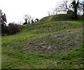
Remains of Loughor Castle
The castle was built c1106 by the Anglo-Norman lord Henry de Beaumont, during the Norman invasion of Wales. The site overlooking the River Loughor controlled a strategic road and ford running across the Gower Peninsula.
In 2016, the remains of Loughor Castle are controlled by the Welsh heritage agency Cadw. The ruined tower and fragments of the curtain wall are on top of the earthwork defences which resemble a motte or mound.
Image: © Jaggery
Taken: 25 Mar 2016
0.02 miles
7
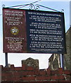
Information board, St Michael's Church, Loughor
Facing Station Road here. http://www.geograph.org.uk/photo/4925250
Image: © Jaggery
Taken: 25 Mar 2016
0.02 miles
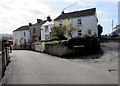
8
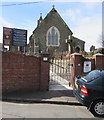
Entrance to St Michael's Church, Loughor
From Station Road. St Michael's Church http://www.geograph.org.uk/photo/4925213 is in the Church in Wales Parish of Loughor in the Diocese of Swansea and Brecon. http://www.geograph.org.uk/photo/4925261 to a closer view of the information board.
Image: © Jaggery
Taken: 25 Mar 2016
0.02 miles
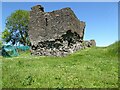
9
Loughor Castle
A ruined, medieval fortification, built around 1106 by the Anglo-Norman lord Henry de Beaumont, during the Norman invasion of Wales. Viewed from Castle Street.
Image: © Eirian Evans
Taken: 22 May 2022
0.02 miles
10
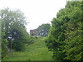
Glimpse of Loughor Castle from the Wales Coast Path
A ruined, medieval fortification, built around 1106 by the Anglo-Norman lord Henry de Beaumont, during the Norman invasion of Wales.
Image: © Eirian Evans
Taken: 22 May 2022
0.02 miles