IMAGES TAKEN NEAR TO
Poppit, CARDIGAN, SA43 3LW
Introduction
This page details the photographs taken nearby to SA43 3LW by members of the Geograph project.
The Geograph project started in 2005 with the aim of publishing, organising and preserving representative images for every square kilometre of Great Britain, Ireland and the Isle of Man.

There are currently over 7.5m images from over14,400 individuals and you can help contribute to the project by visiting https://www.geograph.org.uk
Image Map (Loading...)


Getting Data...Please wait
Leaflet Map data © OpenStreetMap
Images are licensed for reuse under creativecommons.org/licenses/by-sa/2.0
Notes
- Clicking on the map will re-center to the selected point.
- The higher the marker number, the further away the image location is from the centre of the postcode.
Image Listing (4 Images Found)
Images are licensed for reuse under creativecommons.org/licenses/by-sa/2.0
Image
Details
Distance
1
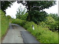
Footpath to Manian Fawr
After passing Manian Fawr this footpath emerges onto the St Dogmael's to Poppit Sands road.
Image: © Philip Halling
Taken: 7 May 2007
0.17 miles
2
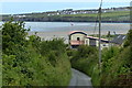
Lane descending towards Poppit Sands
The village of Gwbert in Ceredigion is a mile away along Cardigan Bay.
Image: © Mat Fascione
Taken: 3 Jun 2019
0.24 miles
3
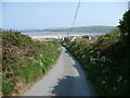
Lane above Poppit Sands
The lane rises as it climbs towards Cemaes Head and offers the first of many enticing views of the wide expanses of Poppit Sands.
Image: © Jeremy Bolwell
Taken: 30 Apr 2011
0.25 miles