IMAGES TAKEN NEAR TO
Bank Farm, SWANSEA, SA3 1LL
Introduction
This page details the photographs taken nearby to Bank Farm, SA3 1LL by members of the Geograph project.
The Geograph project started in 2005 with the aim of publishing, organising and preserving representative images for every square kilometre of Great Britain, Ireland and the Isle of Man.

There are currently over 7.5m images from over14,400 individuals and you can help contribute to the project by visiting https://www.geograph.org.uk
Image Map
Images are licensed for reuse under creativecommons.org/licenses/by-sa/2.0
Notes
- Clicking on the map will re-center to the selected point.
- The higher the marker number, the further away the image location is from the centre of the postcode.
Image Listing (20 Images Found)
Images are licensed for reuse under creativecommons.org/licenses/by-sa/2.0
Image
Details
Distance
1
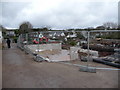
New developments at the caravan park at Horton
Construction is underway on something, but at this stage it is hard to say what it might be. It has a 'wet room' though...
Image: © Jeremy Bolwell
Taken: 27 Feb 2011
0.03 miles
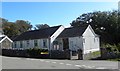
2
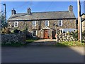
Great House Farm
Farmhouse at the top of the village of Horton.
Image: © Alan Hughes
Taken: 21 Feb 2019
0.03 miles
3
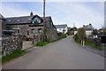
Road in Horton
This is the top segment of a circle of roads in the village, which enables buses to turnround easily.
Image: © Bill Boaden
Taken: 12 Apr 2016
0.04 miles
4
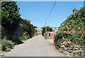
Street in Horton going uphill
The streets in Horton form a sort of square so it has a one way system with an up road and a down road, which avoids many of the usual narrow lane encounters.
Image: © Des Blenkinsopp
Taken: 20 Jul 2021
0.04 miles
5

Old sign at a caravan park above Port -Eynon on Gower
The sign seems long gone but the frame remains beside a roadway and footpath. Beyond a view towards Port-Eynon village and its caravan parks.
Image: © Jeremy Bolwell
Taken: 27 Feb 2011
0.11 miles
6

Ground excavation
Construction of rocky base for property development in the village of Horton.
Image: © Alan Hughes
Taken: 21 Feb 2019
0.11 miles
7
Horton village hall
The village hall stands near the top end of the village which extends down two steep hills towards the shoreline.
Image: © Gordon Hatton
Taken: 25 Sep 2016
0.12 miles
8

The village of Horton
Road leading from the village of Horton.
Image: © Alan Hughes
Taken: 21 Feb 2019
0.15 miles
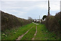
9

Green lane
Green lane leading from the village of Scurlage to Horton.
Image: © Alan Hughes
Taken: 21 Feb 2019
0.15 miles
10
Track to Horton
Formerly a farm track, now servicing the caravan site that occupies former fields above the village.
Image: © Bill Boaden
Taken: 12 Apr 2016
0.15 miles