IMAGES TAKEN NEAR TO
Highland Terrace, SWANSEA, SA2 7SU
Introduction
This page details the photographs taken nearby to Highland Terrace, SA2 7SU by members of the Geograph project.
The Geograph project started in 2005 with the aim of publishing, organising and preserving representative images for every square kilometre of Great Britain, Ireland and the Isle of Man.

There are currently over 7.5m images from over14,400 individuals and you can help contribute to the project by visiting https://www.geograph.org.uk
Image Map
Images are licensed for reuse under creativecommons.org/licenses/by-sa/2.0
Notes
- Clicking on the map will re-center to the selected point.
- The higher the marker number, the further away the image location is from the centre of the postcode.
Image Listing (23 Images Found)
Images are licensed for reuse under creativecommons.org/licenses/by-sa/2.0
Image
Details
Distance
1
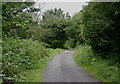
Highland Terrace
This lane leads into a nature reserve which was originally a site of industrial activities such as coal mining, quarrying and brick making.
Image: © john bristow
Taken: 8 Aug 2012
0.05 miles
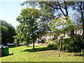
2
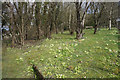
The Olde Post Office Park
One must assume that there used to be a post office here. It currently has a good display of primroses.
Image: © Bill Boaden
Taken: 6 Apr 2016
0.06 miles
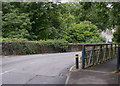
3
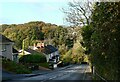
Dunvant Road near the former railway bridge
Image: © john bristow
Taken: 26 Oct 2020
0.07 miles
4
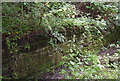
The southbound platform face of the former Dunvant station
This platform, or what's left of it, is now on the Clyne Trail.
Image: © john bristow
Taken: 8 Aug 2012
0.07 miles
5
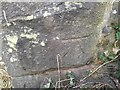
Ordnance Survey Cut Mark
This OS cut mark can be found on the SE buttress of the railway bridge. It marks a point 175.4ft above mean sea level.
Image: © Adrian Dust
Taken: 15 Feb 2023
0.08 miles
6
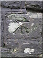
Ordnance Survey Cut Mark
This OS cut mark can be found on the NE parapet of the railway bridge. It marks a point 59.612m above mean sea level.
Image: © Adrian Dust
Taken: 13 Dec 2015
0.09 miles
7
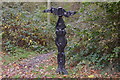
Signpost on the Clyne Trail
The design of this modern 'sculpture' reflects the rich industrial history of the Dunvant area.
Image: © john bristow
Taken: 25 Oct 2012
0.09 miles
8
Llwybr Beicio Dyfnant/ Dunvant Cycle Path
Llwybr troed yn gadael y ffordd seiclo ger hen Orsaf Reilfordd y Dyfnant. Caewyd y lein yn 1964 gan fwyell Beeching.
A footpath leaving the cycle path near Dunvant < Dyfnant (trans deep valley) near the former Dunvant Railway Station. The line closed in 1964 by the now infamous Beeching Axe.
Image: © Alan Richards
Taken: 5 Jan 2015
0.10 miles
9
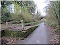
Dunvant Bridge
This bridge carries the B4296 road over the Clyne Trail, formally a railway closed in 1964. The bridge experiences fairly regular collisions due to its sinuous alignment and its location at the bottom of a steep hill.
Image: © john bristow
Taken: 8 Aug 2012
0.11 miles
10
Houses on Walters Row, Dunvant
Seen from the Clyne Trail carpark, looking west.
Image: © Simon Mortimer
Taken: 9 Aug 2012
0.12 miles