IMAGES TAKEN NEAR TO
Crescent Road, LLANDEILO, SA19 6HN
Introduction
This page details the photographs taken nearby to Crescent Road, SA19 6HN by members of the Geograph project.
The Geograph project started in 2005 with the aim of publishing, organising and preserving representative images for every square kilometre of Great Britain, Ireland and the Isle of Man.

There are currently over 7.5m images from over14,400 individuals and you can help contribute to the project by visiting https://www.geograph.org.uk
Image Map
Images are licensed for reuse under creativecommons.org/licenses/by-sa/2.0
Notes
- Clicking on the map will re-center to the selected point.
- The higher the marker number, the further away the image location is from the centre of the postcode.
Image Listing (195 Images Found)
Images are licensed for reuse under creativecommons.org/licenses/by-sa/2.0
Image
Details
Distance
1
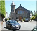
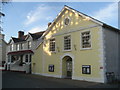
St Paul's Court, Llandeilo
Built in 1900 as St Paul's Welsh Methodist church. Soon after closure in the early 1990s, the church was converted into 4 flats.
Image: © Jaggery
Taken: 26 Jun 2011
0.01 miles
2
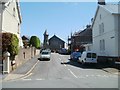
Latimer Road, Llandeilo
Viewed from Crescent Road. The churchlike building http://www.geograph.org.uk/photo/2478515 in the distance was indeed formerly a church. The building was converted into 4 flats in the 1990s.
Image: © Jaggery
Taken: 26 Jun 2011
0.01 miles
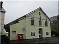
3
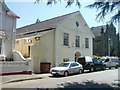
Llandeilo Civic Hall
Located on Crescent Road. The hall was built in 1887 to mark the golden jubilee of Queen Victoria's accession in 1837. For many years in use as a Territorial Army Drill Hall, in the 1970s it was taken over by the local council for use as a multi-purpose civic and community hall.
The building at the right edge of the view is Capel Newydd. http://www.geograph.org.uk/photo/2478639
Image: © Jaggery
Taken: 26 Jun 2011
0.01 miles
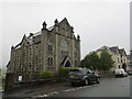
4
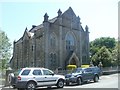
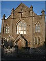
Capel Newydd, Llandeilo
Independent chapel on Crescent Road. The foundation stone was laid in 1901. It is next door to Llandeilo Civic Hall, http://www.geograph.org.uk/photo/2478608 built 14 years earlier.
Image: © Jaggery
Taken: 26 Jun 2011
0.01 miles
5
Civic Hall
On Crescent Road. Centre for community activities.
Image: © Trevor Rickard
Taken: 22 Aug 2007
0.02 miles
6
Capel Newydd, Llandeilo
Date from 1901. Architect Henry Herbert.
Image: © Jonathan Thacker
Taken: 23 Jun 2017
0.02 miles
8
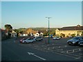
Llandeilo's main car park
With chapel on Crescent Road and the library on the right
Image: © Antony Dixon
Taken: 14 Jun 2018
0.03 miles
9
Capel Newydd
On Crescent Road. Independent church built in 1901 by Henry Herbert.
Image: © Trevor Rickard
Taken: 22 Aug 2007
0.03 miles
10
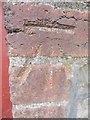
Ordnance Survey Cut Mark
This OS Cut Mark can be found on the N face of Cartrefle House, Crescent Rd. It marks a point 57.9192m above mean sea level.
Image: © Adrian Dust
Taken: 28 Jul 2013
0.04 miles