IMAGES TAKEN NEAR TO
Marcroft Road, SWANSEA, SA1 8NH
Introduction
This page details the photographs taken nearby to Marcroft Road, SA1 8NH by members of the Geograph project.
The Geograph project started in 2005 with the aim of publishing, organising and preserving representative images for every square kilometre of Great Britain, Ireland and the Isle of Man.

There are currently over 7.5m images from over14,400 individuals and you can help contribute to the project by visiting https://www.geograph.org.uk
Image Map
Images are licensed for reuse under creativecommons.org/licenses/by-sa/2.0
Notes
- Clicking on the map will re-center to the selected point.
- The higher the marker number, the further away the image location is from the centre of the postcode.
Image Listing (24 Images Found)
Images are licensed for reuse under creativecommons.org/licenses/by-sa/2.0
Image
Details
Distance
1
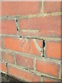
Ordnance Survey Cut Mark
This OS cut mark can be found on the wall below No327 Dan Y Graig Road. It marks a point 18.349m above mean sea level.
Image: © Adrian Dust
Taken: 1 Nov 2015
0.07 miles
2
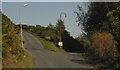
Junction of Dinam Road and Tir-John Civic Amenities Site
Image: © Cedwyn Davies
Taken: 9 Sep 2006
0.07 miles
4
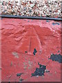
Ordnance Survey Pivot
This OS pivot can be found on No56 Wern Terrace. It marks a point 13.521m above mean sea level.
Image: © Adrian Dust
Taken: 1 Nov 2015
0.14 miles
5
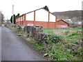
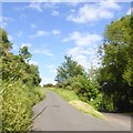
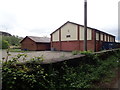
Ashlands Sports Centre (Port Tennant)
Ashlands Sports Centre is located at Wern Fawr Road, Port Tennant, Swansea, SA1 8LQ.
This photograph was taken from the path that runs alongside the disused railway lines that headed towards Burrows Sidings.
The sports centre and its pitches occupy the former 'Carbon Black' works operated by the now defunct United Carbon Black Ltd. The plant which opened in 1948 made 'Dixie and Kosmos grade' carbon black - substances used in the manufacture of tyres and other rubber products. A tar distillery was located next to the works until the 1970s.
The Ecologist magazine (Vol 1 No 12 June 1971) documented just how Swansea's residents had suffered for 21 years as a result of the pollution caused by this plant. In 1970 the plant planned to increase production of its carbon black products by 35%, however by 1971 United Carbon Black Ltd was forced to spend money (£35,000 - 1971 prices) in order to improve air emissions as a result of a vigorous local pressure group (Box, S. 1983; The National Archives FD 9/1396)
United Carbon Black Sales Limited was struck off from the companies register in 1979 (p2883, London Gazette 2nd March 1979). United Carbon Black Ltd became Ashland United Kingdom Chemical Ltd. The site was cleared in the 1980s. The walls before the sports centre date back to the original plant.
Image: © vectorkraft
Taken: 5 Dec 2011
0.14 miles
7
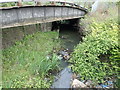
Tennant Canal (Wern Fawr Road)
This is a view of the Tennant Canal as seen from the eastern extremity of Wern Fawr Road. The canal led into Swansea Docks until the 1950s (albeit marked as disused on maps); official canal freight operations ceased as early as 1920.
The railway viaduct carried freight into Burrows Sidings until the late 1980s. There was a connection with the Marcroft Wagon Works just to the right of this position until the 1990s.
The condition of this canal (in 2011) improves as you travel towards Jersey Marine and Neath.
Image: © vectorkraft
Taken: 5 Dec 2011
0.16 miles
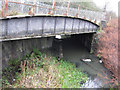
8
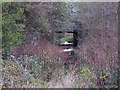
Railway viaduct at the western end of the Tennant Canal
The Tennant Canal connected to Swansea Docks until the 1950's. This sad section is now strewn with rubbish.
Image: © Eirian Evans
Taken: 6 May 2019
0.17 miles
9
Tennant Canal (Fabian Way)
Today, this is the start of the Tennant Canal as seen from Fabian Way. Prior to the 1960s and the building of Fabian Way, the canal continued into Swansea Docks, although this navigation had been marked as disused since the 1920s.
Completed in 1824, the canal originally continued from this position in the photograph towards the eastern end of the Prince of Wales Dock - this being the original ‘Tennants Wharf’. A diversion was created c1905 to take the canal towards the newly built Kings Dock.
By 1920, all freight operations on the canal had ceased and the lock into the Kings Dock had been blocked off. Despite this, the basic canal remained in fairly good condition until the late 1930s. After this period, the canal became less navigable and is from this point marked as 'Tennant Canal (disused)' on maps. Substantial decay of the route followed.
By the 1950s the Kings Dock connection was filled in and by the 1960s the canal had receded as far as this position shown in the photograph above due to road construction.
The condition of this canal (in 2011) improves as you travel towards Jersey Marine and Neath.
Image: © vectorkraft
Taken: 5 Dec 2011
0.19 miles
10
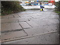
Fabian Way - Wern Fawr Road level crossing
These railway lines originally formed part of the Vale of Neath Railway dating back to the 19th Century.
In the early 1980s, the access road shown was laid as a convenient access route to the former railway wagon repair works sited on Wern Fawr Road (Marcroft Wagon Works). The building of this road necessitated a new level crossing which had not existed previously. This road continues to be used by lorries heading for the Tir John landfill site.
The lines were thought to be last used in the late 1980s (or very early 1990s) and originally led to Burrows Sidings to the east. A signal cabin was located just to the left of this view up until the 1950s. A 1917 OS Map shows there was an additional signal cabin just to the right of this view, although this had gone by the 1940s.
This access road is unnamed, but runs from Fabian Way to Wern Fawr Road. A new estate of houses occupies the former wagon works.
Image: © vectorkraft
Taken: 5 Dec 2011
0.19 miles