IMAGES TAKEN NEAR TO
Tir Syr Walter, AMMANFORD, SA18 1JW
Introduction
This page details the photographs taken nearby to Tir Syr Walter, SA18 1JW by members of the Geograph project.
The Geograph project started in 2005 with the aim of publishing, organising and preserving representative images for every square kilometre of Great Britain, Ireland and the Isle of Man.

There are currently over 7.5m images from over14,400 individuals and you can help contribute to the project by visiting https://www.geograph.org.uk
Image Map (Loading...)


Getting Data...Please wait
Leaflet Map data © OpenStreetMap
Images are licensed for reuse under creativecommons.org/licenses/by-sa/2.0
Notes
- Clicking on the map will re-center to the selected point.
- The higher the marker number, the further away the image location is from the centre of the postcode.
Image Listing (7 Images Found)
Images are licensed for reuse under creativecommons.org/licenses/by-sa/2.0
Image
Details
Distance
1
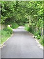
Amman valley cycleway
This is a relatively recently completed section of the Amman valley cycleway. Other sections either side of it have existed for longer.
See Image for a view (in the opposite direction) of the dismantled railway that this section is built on.
Image: © Nigel Davies
Taken: 9 Jun 2013
0.13 miles
2
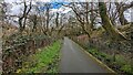
Cycle Path between Garnant and Brynamman
Image: © Sandy Gerrard
Taken: 3 Apr 2024
0.15 miles
3
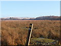
Llwybr Cwm Aman Footpath
Mae'r llwybr cyhoeddus yn arwain drwy'r brwyn at Barc Natur Ynys Dawela. Gan amlaf porir y tir gan dda ac mae'r postyn, wrth ei siap, wedi bod yn gyfleus iawn i rwto yn ei erbyn.
The footpath leads through the rushes towards Ynys Dawela Nature Reserve. The field is usually grazed by cattle and judging by the shape of the waymarker it has become a very convenient rubbing post.
Image: © Alan Richards
Taken: 5 Dec 2010
0.17 miles
4
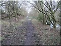
Old railway course
This is the course of the old Brynamman branch railway which used to run from Brynamman to Llanelli. Much of the line still exists, though the section that runs up the Amman Valley is now only maintained as a branch line. The final section to Brynamman was lifted in the 1950s.
Image: © Hywel Williams
Taken: 10 Feb 2007
0.17 miles
5
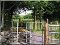
Footpath junction
Three footpaths diverging from the dead end of this road.
Image: © Marion Phillips
Taken: 6 Jul 2010
0.19 miles
6
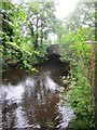
Bridge over the River Amman
The Bridge carries the Nant Gwineu Road over the River Amman.
Image: © Adrian Dust
Taken: 4 Jul 2013
0.22 miles
7
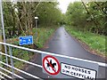
Cycle route to Brynaman
Or indeed 'Brynamman' as the sign would have it. This (in May 2014) is one of the most recently opened sections of the route through Dyffryn Aman and also gives access to those on foot too to a previously more secretive section of the river valley.
Image: © Alan Bowring
Taken: 10 May 2014
0.25 miles