IMAGES TAKEN NEAR TO
FERRYSIDE, SA17 5TN
Introduction
This page details the photographs taken nearby to SA17 5TN by members of the Geograph project.
The Geograph project started in 2005 with the aim of publishing, organising and preserving representative images for every square kilometre of Great Britain, Ireland and the Isle of Man.

There are currently over 7.5m images from over14,400 individuals and you can help contribute to the project by visiting https://www.geograph.org.uk
Image Map
Images are licensed for reuse under creativecommons.org/licenses/by-sa/2.0
Notes
- Clicking on the map will re-center to the selected point.
- The higher the marker number, the further away the image location is from the centre of the postcode.
Image Listing (30 Images Found)
Images are licensed for reuse under creativecommons.org/licenses/by-sa/2.0
Image
Details
Distance
1
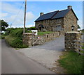
Ferryside Farmhouse
Self-catering or B&B holiday home set back from a lane, near Ferryside Farm touring caravan & campsite.
Image: © Jaggery
Taken: 4 Jul 2015
0.00 miles
2
Wales Coast Path in the west of Ferryside
Viewed across Carmarthen Road near Ystrad Bridge. http://www.geograph.org.uk/photo/4553911 Signs shows that this is not a through route for motor vehicles. For walkers and cyclists, this is part of the Wales Coast Path, a 1,400km long footpath alongside or near most of the coastline of Wales.
Image: © Jaggery
Taken: 4 Jul 2015
0.05 miles
3
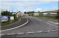
Ferryside Farm touring caravan & campsite, Ferryside
Entrance from Carmarthen Road.
Image: © Jaggery
Taken: 4 Jul 2015
0.05 miles
4
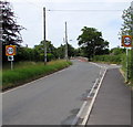
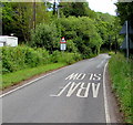
Start of the 30 zone at the western edge of Ferryside
The 40mph speed limit along Carmarthen Road drops to 30 on the approach to Ystrad Bridge. http://www.geograph.org.uk/photo/4553911
Image: © Jaggery
Taken: 4 Jul 2015
0.07 miles
5
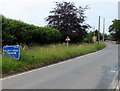
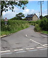
Western boundary of Ferryside
The sign is alongside Carmarthen Road.
Image: © Jaggery
Taken: 4 Jul 2015
0.08 miles
6
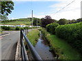
Drainage channel alongside Carmarthen Road, Ferryside
Viewed from Ystrad Bridge. http://www.geograph.org.uk/photo/4553911 The channel empties into the River Towy (Afon Tywi in Welsh) estuary.
Image: © Jaggery
Taken: 4 Jul 2015
0.08 miles
7
Ystrad Bridge, Ferryside
The bridge carries Carmarthen Road over a streamlike drainage channel. http://www.geograph.org.uk/photo/4322296 to a side view of the bridge.
Image: © Jaggery
Taken: 4 Jul 2015
0.08 miles
8
Bends for one mile ahead east of Ferryside
Carmarthen Road east of the Ferryside boundary sign. http://www.geograph.org.uk/photo/4560158
Image: © Jaggery
Taken: 4 Jul 2015
0.08 miles
9
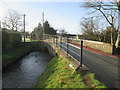
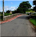
Ystrad Bridge
There is an Ordnance Survey cut mark on the west parapet as well as a plaque which states the bridge was built in 1870. On the northern end of the east parapet is an Environmental Agency Bench Mark (EABM). http://www.geograph.org.uk/photo/4322295
Image: © Adrian Dust
Taken: 24 Jan 2015
0.09 miles
10
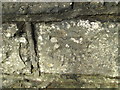
Ordnance Survey Cut Mark
This OS cut mark can be found on the west parapet of Ystrad Bridge. It marks a point 6.1521m above mean sea level. http://www.geograph.org.uk/photo/4322296
Image: © Adrian Dust
Taken: 24 Jan 2015
0.09 miles