IMAGES TAKEN NEAR TO
Tyisha Road, LLANELLI, SA14 6HA
Introduction
This page details the photographs taken nearby to Tyisha Road, SA14 6HA by members of the Geograph project.
The Geograph project started in 2005 with the aim of publishing, organising and preserving representative images for every square kilometre of Great Britain, Ireland and the Isle of Man.

There are currently over 7.5m images from over14,400 individuals and you can help contribute to the project by visiting https://www.geograph.org.uk
Image Map
Images are licensed for reuse under creativecommons.org/licenses/by-sa/2.0
Notes
- Clicking on the map will re-center to the selected point.
- The higher the marker number, the further away the image location is from the centre of the postcode.
Image Listing (17 Images Found)
Images are licensed for reuse under creativecommons.org/licenses/by-sa/2.0
Image
Details
Distance
1
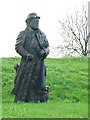
Wooden sculpture in Tumble park
A small park in a side street in Tumble contains this carved statue. There is no text to accompany it.
The chap is wearing a suit and bowler hat and carrying a cane. However he also has big boots, a huge beard and a coiled rope in his coat pocket.
Sadly the dog at his feet has lost his snout to vandals or the elements.
Image: © Nigel Davies
Taken: 25 Nov 2006
0.11 miles
2
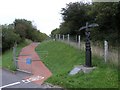
Cycle route along an old railway line
This is part of Sustrans national cycle route 47 which at this stage follows an abandoned railway line for several miles. A Dudgen type mile post (one of only two of this type in Wales) can be seen giving directions to Llanelli and Porthyrhyd.
The plaque in front of the post is a Welsh translation of some English text on the post.
Image: © Hywel Williams
Taken: 8 Oct 2006
0.15 miles
5
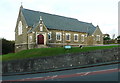
St David's Church. Tumble
"Dewi Sant was built in 1926-7. The church was built to the designs of William Griffiths and was raised by miners during the General strike." (from https://www.seearoundbritain.com/venues/tumble-st-davids-church-open-daily-free-entry )
Image: © Humphrey Bolton
Taken: 26 Oct 2016
0.17 miles
7
Cycle route waymarker, Tumble
This Sustrans waymarker on cycle route 47 is right beside the main road from upper Tumble to lower. The arms point to Porthyrhyd and Llanelli.
Image: © Nigel Davies
Taken: 25 Nov 2006
0.17 miles
8
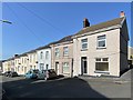
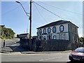
The Great Mountain Workingmens Club - Tumble
The title shown is as displayed above the door of the club.
Image: © Mick Lobb
Taken: 7 Apr 2009
0.18 miles
9
Workingmen?s Club
Tumble workingmen’s club.
Image: © Alan Hughes
Taken: 17 Sep 2020
0.18 miles
10
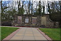
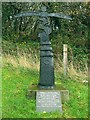
War memorial at Tumble
The memorial includes commemorative tablets in respect of mining in the area.
Image: © Mick Lobb
Taken: 7 Apr 2009
0.23 miles