IMAGES TAKEN NEAR TO
Margam Road, PORT TALBOT, SA13 2BU
Introduction
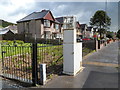
This page details the photographs taken nearby to Margam Road, SA13 2BU by members of the Geograph project.
The Geograph project started in 2005 with the aim of publishing, organising and preserving representative images for every square kilometre of Great Britain, Ireland and the Isle of Man.

There are currently over 7.5m images from over14,400 individuals and you can help contribute to the project by visiting https://www.geograph.org.uk
Image Map
Images are licensed for reuse under creativecommons.org/licenses/by-sa/2.0
Notes
- Clicking on the map will re-center to the selected point.
- The higher the marker number, the further away the image location is from the centre of the postcode.
Image Listing (37 Images Found)
Images are licensed for reuse under creativecommons.org/licenses/by-sa/2.0
Image
Details
Distance
1
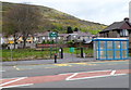
Roadside monitoring equipment, Margam, Port Talbot
Located between Margam Road (the A48) and Twll-yn-y-Wal Park. http://www.geograph.org.uk/photo/2949512
I don't know what the equipment is monitoring - perhaps roadside air pollution, or maybe air temperature, to indicate when road gritting is needed.
Image: © Jaggery
Taken: 19 Apr 2012
0.03 miles
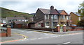
2
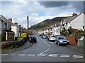
Margam Road houses, Margam, Port Talbot
Viewed from near the corner of Stallcourt Road.
Image: © Jaggery
Taken: 19 Apr 2012
0.03 miles
3

Ordnance Survey Cut Mark
This OS cut mark can be found on the outbuilding of No163 Margam Road. It marks a point 10.031m above mean sea level.
Image: © Adrian Dust
Taken: 6 May 2020
0.03 miles
4
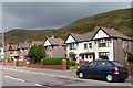
Margam
Northern end of Pant Celydd. Mynydd Brombil rises behind Margam.
Image: © Eirian Evans
Taken: 6 May 2019
0.03 miles
5
Corner of Margam Road and Stallcourt Road, Margam, Port Talbot
Viewed from Margam Road (the A48).
Image: © Jaggery
Taken: 19 Apr 2012
0.05 miles
6
Wern Road, Margam, Port Talbot
Viewed from the Ty Fry Road end, near St David's church. http://www.geograph.org.uk/photo/2950525
Image: © Jaggery
Taken: 19 Apr 2012
0.05 miles
8
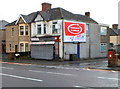
Corner of Margam Road and Graig Avenue, Margam, Port Talbot
There is a wall-mounted post box on the right side of the corner. On the left side is an empty shop, formerly Ruby's Razors. "Ruby" shows in the part of the name sign remaining on the wall.
There is a large Colgate toothpaste advert on the side wall.
Image: © Jaggery
Taken: 19 Apr 2012
0.08 miles
9
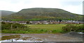
A distant view of the Margam Mountain plateau
Viewed from the edge of the South Wales main railway line http://www.geograph.org.uk/photo/2949570 looking towards Margam Road, which is the subject location of this view. The distant high ground is the Margam Mountain (Mynydd Margam) plateau. Some crests exceed 300m above mean sea level, the highest of which is Margam Mountain itself, at 342m.
Image: © Jaggery
Taken: 19 Apr 2012
0.08 miles
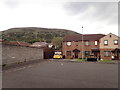
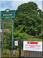
10
Twll-yn-y-Wal Park, Margam, Port Talbot
This small (35 metres by 30 metres) area of greenery is alongside Margam Road (the A48).
The park's name is Welsh for Hole-in-the-wall.
Image: © Jaggery
Taken: 19 Apr 2012
0.08 miles