IMAGES TAKEN NEAR TO
Darton Road, BARNSLEY, S75 4JA
Introduction
This page details the photographs taken nearby to Darton Road, S75 4JA by members of the Geograph project.
The Geograph project started in 2005 with the aim of publishing, organising and preserving representative images for every square kilometre of Great Britain, Ireland and the Isle of Man.

There are currently over 7.5m images from over14,400 individuals and you can help contribute to the project by visiting https://www.geograph.org.uk
Image Map
Images are licensed for reuse under creativecommons.org/licenses/by-sa/2.0
Notes
- Clicking on the map will re-center to the selected point.
- The higher the marker number, the further away the image location is from the centre of the postcode.
Image Listing (20 Images Found)
Images are licensed for reuse under creativecommons.org/licenses/by-sa/2.0
Image
Details
Distance
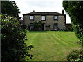
2
Cinder Hill farmhouse, Cawthorne
The 17th-18th century farmhouse is grade II listed (list entry 1286832) as is the late 18th century ha-ha in front of it (1151783), crossed here by a few steps and an unusual feature for a modest property.
Image: © Stephen Craven
Taken: 17 Oct 2019
0.01 miles
3
Cinder Hill Farm, Cawthorne
The livestock farm has diversified into providing camping facilities and hosting music festivals.
Image: © Stephen Craven
Taken: 17 Oct 2019
0.03 miles
4
Cinder Hill campsite, Cawthorne
Certificated by the Camping and Caravanning Club, but there were no midweek visitors in October.
Image: © Stephen Craven
Taken: 17 Oct 2019
0.04 miles
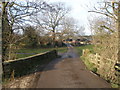
6
Cinder Hill bridge, Cawthorne
A bridge over the Cawthorne Dike that gives access to the farm of the same name.
Image: © Stephen Craven
Taken: 17 Oct 2019
0.06 miles
7
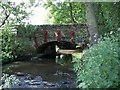
Cinder Hill Bridge
Over Cawthorne Dike, note the new red tie bars that strengthen the bridge. This is the only access to Cinder Hill Farm.
Image: © John Fielding
Taken: 29 May 2008
0.08 miles
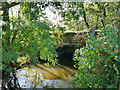
9
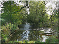
Weir on the Cawthorne Dike - top view
The weir's purpose was to feed a mill race to a mill several hundred metres further east, of which there is now no trace Image
Image: © Stephen Craven
Taken: 17 Oct 2019
0.12 miles
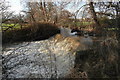
10
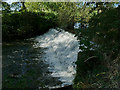
Weir on the Cawthorne Dike - side view
The weir's purpose was to feed a mill race to a mill several hundred metres further east, of which there is now no trace Image
Image: © Stephen Craven
Taken: 17 Oct 2019
0.12 miles