IMAGES TAKEN NEAR TO
Bark House Lane, BARNSLEY, S75 4AS
Introduction
This page details the photographs taken nearby to Bark House Lane, S75 4AS by members of the Geograph project.
The Geograph project started in 2005 with the aim of publishing, organising and preserving representative images for every square kilometre of Great Britain, Ireland and the Isle of Man.

There are currently over 7.5m images from over14,400 individuals and you can help contribute to the project by visiting https://www.geograph.org.uk
Image Map (Loading...)


Getting Data...Please wait
Leaflet Map data © OpenStreetMap
Images are licensed for reuse under creativecommons.org/licenses/by-sa/2.0
Notes
- Clicking on the map will re-center to the selected point.
- The higher the marker number, the further away the image location is from the centre of the postcode.
Image Listing (16 Images Found)
Images are licensed for reuse under creativecommons.org/licenses/by-sa/2.0
Image
Details
Distance
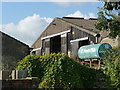
1
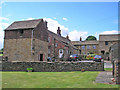
Jowett House Farm
Parts of the farm buildings are Grade II listed and date from 1633.
Image: © John Illingworth
Taken: 11 May 2011
0.01 miles
2
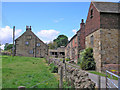
Jowett House Farm
Parts of the farm are Grade II listed and date from 1633.
Image: © John Illingworth
Taken: 11 May 2011
0.01 miles
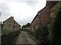
3
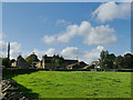
Jowett House farm
The farm has 14th century origins although the present buildings, some of which are grade II listed, date from the 17th century onwards, see http://midgleywebpages.com/jowetthouse.html for a more detailed history. See Image and Image for closer views.
Image: © Stephen Craven
Taken: 17 Oct 2019
0.01 miles
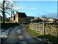
4
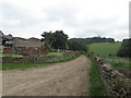
Farm track and footpath at Jowett House Farm
Image: © John Slater
Taken: 30 Sep 2013
0.01 miles
5
Milk tank at Jowett House farm
The farm supplies (or at least used to supply) the Co-Operative.
Image: © Stephen Craven
Taken: 17 Oct 2019
0.01 miles
6

At Jowett House Farm
The main subject of this picture is the eighteenth century listed dovecot with cart shed beneath.
Image: © Neil Theasby
Taken: 31 Jul 2016
0.01 miles
7
Jowett House Farm
Jowett House was originally called Oakenthorpe Mill
Image: © Nigel Homer
Taken: 26 Dec 2005
0.03 miles
9
View north from Jowett House Lane
Beyond the trees is New Road (not so new - it's appeared on maps for over 100 years).
Image: © Stephen Craven
Taken: 17 Oct 2019
0.15 miles
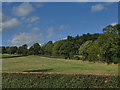
10
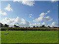
Maize field at Jowett House farm
This appears to be the location for a seasonal 'maize maze', the pattern of which is not visible from ground level.
Image: © Stephen Craven
Taken: 17 Oct 2019
0.15 miles