IMAGES TAKEN NEAR TO
Wentworth Way, BARNSLEY, S75 3DH
Introduction
This page details the photographs taken nearby to Wentworth Way, S75 3DH by members of the Geograph project.
The Geograph project started in 2005 with the aim of publishing, organising and preserving representative images for every square kilometre of Great Britain, Ireland and the Isle of Man.

There are currently over 7.5m images from over14,400 individuals and you can help contribute to the project by visiting https://www.geograph.org.uk
Image Map
Images are licensed for reuse under creativecommons.org/licenses/by-sa/2.0
Notes
- Clicking on the map will re-center to the selected point.
- The higher the marker number, the further away the image location is from the centre of the postcode.
Image Listing (13 Images Found)
Images are licensed for reuse under creativecommons.org/licenses/by-sa/2.0
Image
Details
Distance
1

Two of a kind
Post boxes in Tankersley Industrial Estate.
Image: © Steve Fareham
Taken: 20 May 2008
0.11 miles
2
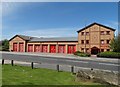
South Yorkshire Fire Station at Tankersley
Tankersley is a full time station providing fire cover to the residential areas of Hoyland, Birdwell, Wosborough, High Green and Chapeltown and also provides the first attendance to the smaller villages of Pilley, Tankersley, Wortley and Harley. Industrial and commercial areas covered include the Tankersley Platts Common and Chapeltown industrial estates. The station also provides the initial response to the M1, junctions 34-37, the A61 and the A616 Stocksbridge by-pass for road traffic collisions.
Image: © Neil Theasby
Taken: 11 May 2015
0.11 miles
3

Temple of Trade
Jacquet UK is a service oriented stainless and nickel alloy processing company. Why they chose a mock-classical frontage to this functional commercial building is a mystery.
Image: © Neil Theasby
Taken: 11 May 2015
0.13 miles

5
Tankersley Fire Station
Sited in the middle of the Industrial Estate on the site of the former Wharncliffe Silkstone Colliery.
Image: © Wendy North
Taken: 26 Jul 2008
0.15 miles
6

Potter Holes Hill
Walked up to gate in hedge in sheep field with Martin Richardson. This reclaimed land from mining has been altered and does not agree with OS map. The contours and 180m spot height on 25k map erroneous, estimate height at gate in hedge SK 3393 9994 to be 165m. Tump deleted and hill is Unclassified November 2014
Image: © Rude Health
Taken: 23 Nov 2014
0.16 miles
7
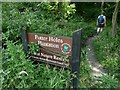
Potter Holes Plantation
At this point we made the mistake of following the Timberland Trail signs which took us back in a northerly direction towards Upper Tankersley. Though the coolness of the woodland was a pleasant change from the mid-day sun.
Image: © Wendy North
Taken: 26 Jul 2008
0.17 miles
8
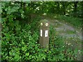
Alternative route - Potter Wood Plantation
The route up these steps would probably taken us closer to our next destination - Church Lane which runs up the eastern edge of Tankersley Manor. See previous image Image
Image: © Wendy North
Taken: 26 Jul 2008
0.17 miles
9
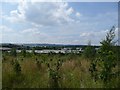
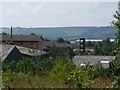
Wentworth Industrial Park
This newly created industrial estate occupies the site of the former Wharncliffe Silkstone Colliery. This view was taken from the recently created footpath extension of the Timberland Trail (part of the Trans-pennine Trail http://www.transpenninetrail.org.uk/template.asp?ID=0&parentID=481 )
Image: © Wendy North
Taken: 26 Jul 2008
0.17 miles
10
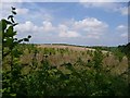
Typical rounded hillside of a former colliery spoil heap
Former spoil heap Wharncliffe Silkstone Colliery - re-seeded and planted.
Image: © Wendy North
Taken: 26 Jul 2008
0.19 miles