IMAGES TAKEN NEAR TO
Hound Hill Lane, BARNSLEY, S70 6TU
Introduction
This page details the photographs taken nearby to Hound Hill Lane, S70 6TU by members of the Geograph project.
The Geograph project started in 2005 with the aim of publishing, organising and preserving representative images for every square kilometre of Great Britain, Ireland and the Isle of Man.

There are currently over 7.5m images from over14,400 individuals and you can help contribute to the project by visiting https://www.geograph.org.uk
Image Map
Images are licensed for reuse under creativecommons.org/licenses/by-sa/2.0
Notes
- Clicking on the map will re-center to the selected point.
- The higher the marker number, the further away the image location is from the centre of the postcode.
Image Listing (34 Images Found)
Images are licensed for reuse under creativecommons.org/licenses/by-sa/2.0
Image
Details
Distance
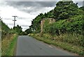
1
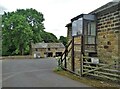
Outbuildings at Houndhill
Houndhill is a substantial Grade II listed Tudor farmhouse (part timber-framed) which dates from the late sixteenth century. Unfortunately, the house itself is not visible from Hound Hill Lane being set back from the road.
Image: © Neil Theasby
Taken: 30 Aug 2022
0.02 miles
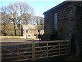
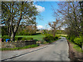
3
Old farm buildings at Hound Hill
With the north-west edge of Worsbrough Country Park in the distance.
Image: © Chris Yeates
Taken: 4 Feb 2006
0.03 miles

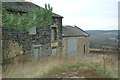
6

Remains of Tower at Hound Hill
Remains of fortifications built around 1642 by Richard Elmhirst, who had sided with the Royalists at the beginning of the English Civil War. The adjoining Grade II listed house is part timber-framed and it remains in the hands of the same family to this day.
Image: © Jonathan Clitheroe
Taken: 27 Jun 2015
0.04 miles
7

Tower at Hound Hill
For information about Hound Hill, see http://www.wikipedia.org/wiki/houndhill
Image: © John Slater
Taken: 23 Nov 2012
0.05 miles
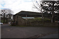
8
Stone tower on Hound Hill Lane
It dates from 1642 and was created under the instructions of Richard Elmhirst, the owner of the adjacent property. He sided with royalists during The English Civil War.
Image: © Neil Theasby
Taken: 30 Aug 2022
0.05 miles
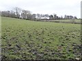
9
Hound Hill Lane, Worsbrough
Pleasant countryside quite near to the Barnsley suburbs.
Image: © Humphrey Bolton
Taken: 30 Apr 2021
0.06 miles
10
Delf House, between Rob Royd and Hound Hill
On a hillside above the Trans Pennine Trail, a former railway line.
Image: © Christine Johnstone
Taken: 19 Mar 2016
0.09 miles