IMAGES TAKEN NEAR TO
Main Street, ROTHERHAM, S60 9ZW

Introduction

This page details the photographs taken nearby to Main Street, S60 9ZW by members of the Geograph project.

The Geograph project started in 2005 with the aim of publishing, organising and preserving representative images for every square kilometre of Great Britain, Ireland and the Isle of Man.

There are currently over 7.5m images from over14,400 individuals and you can help contribute to the project by visiting https://www.geograph.org.uk

Image Map


Images are licensed for reuse under creativecommons.org/licenses/by-sa/2.0
Notes
  • Clicking on the map will re-center to the selected point.
  • The higher the marker number, the further away the image location is from the centre of the postcode.

Image Listing (226 Images Found)

Images are licensed for reuse under creativecommons.org/licenses/by-sa/2.0
  • ...
Image
Details
Distance
1
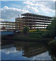
The new Rotherham Metropolitan Borough Council offices reflected in the River Don
Opposite the police station on the brownfield site previously occupied by Guest and Chrimes the steel frame is in an advanced state by Billington Structures Ltd of Barnsley.
Image: © Steve Fareham Taken: 15 Jun 2010
0.02 miles
2
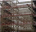
Steel structure for the new Rotherham Metropolitan Borough Council offices
On the site previously occupied in the town centre by Guest and Chrimes. The steel is being supplied and erected by Billington Structures Ltd. of nearby Barnsley.
Image: © Steve Fareham Taken: 15 Jun 2010
0.02 miles
3
Rotherham - Don Street vehicle entrance
To Rotherham Council offices. The solid metal grey gates are to prevent flooding of the offices if the nearby River Don breaks its banks. For an alternative (2010) view, please see Image
Image: © Dave Bevis Taken: 30 Mar 2014
0.03 miles
4
Erection of the steel frame to the new Rotherham Metropolitan Borough Council offices
Steelwork supplied by Billington Structures Ltd of Barnsley to GMI Construction from Leeds.
Image: © Steve Fareham Taken: 15 Jun 2010
0.05 miles
5
Rotherham - Corporation Bridge
Photo taken from Don Street. Left to right can be seen: The Don Navigation towpath. The single-span Corporation Bridge carries Main Street over the Don Navigation. Just beyond the bridge, the waterway splits into two. The left branch is the navigable Rotherham Cut and the right branch leads to a weir on the River Don. Between the two branches is Forge Island, currently home to TESCO. The multi-storey building is the Keppel Wharf office block. The spire of Rotherham Minster can just be seen on the right-hand skyline.
Image: © Dave Bevis Taken: 30 Mar 2014
0.06 miles
6
Rotherham - Don Street and Corporation Bridge
For a more complete photo of Corporation Bridge, please see Image The black-and-white bridge parapet seen in the bottom right-hand quadrant of the photo is a bit of a puzzle. The design suggests that this Don Street bridge was built in the canal-building era. However, I am unsure whether it was an access to a wharf to the west of the Don Navigation or actually part of the Don Navigation prior to 1838. In 1838, the Don Navigation was diverted to make way for the building of the railway from Sheffield to Rotherham Westgate Station. The Wikipedia article at http://en.wikipedia.org/wiki/Rotherham_Westgate_railway_station provides a few clues but not a definitive answer.
Image: © Dave Bevis Taken: 30 Mar 2014
0.06 miles
7
Waterways in Rotherham town centre
Here the Keadby Canal branches left from the River Don
Image: © Neil Theasby Taken: 16 Aug 2012
0.07 miles
8
Two faces of Rotherham
To the left the tower of the old Guest and Chrimes works. This company could trace its origins back to the start of the nineteenth century and became one of the town's major employers - producing a range of metal products for the plumbing industry. To the right you can see the brand new New York Stadium - the new home of Rotherham United F.C..
Image: © Neil Theasby Taken: 16 Aug 2012
0.09 miles
9
Rotherham - Guest & Chrimes Offices
The spire of Rotherham Minster can be seen in the distance.
Image: © Dave Bevis Taken: 10 Mar 2007
0.09 miles
10
Derelict Guest & Chrimes Building on Don Street
Image: © Karl Smt Taken: 20 Dec 2011
0.09 miles
  • ...