IMAGES TAKEN NEAR TO
S60 9HB
Introduction
This page details the photographs taken nearby to S60 9HB by members of the Geograph project.
The Geograph project started in 2005 with the aim of publishing, organising and preserving representative images for every square kilometre of Great Britain, Ireland and the Isle of Man.

There are currently over 7.5m images from over14,400 individuals and you can help contribute to the project by visiting https://www.geograph.org.uk
Image Map
Images are licensed for reuse under creativecommons.org/licenses/by-sa/2.0
Notes
- Clicking on the map will re-center to the selected point.
- The higher the marker number, the further away the image location is from the centre of the postcode.
Image Listing (265 Images Found)
Images are licensed for reuse under creativecommons.org/licenses/by-sa/2.0
Image
Details
Distance
1
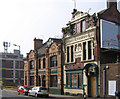
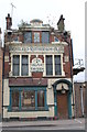
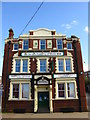
Rotherham - Alma Tavern and Cutlers Arms
Image: © Dave Bevis
Taken: 30 Mar 2014
0.03 miles
3
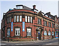
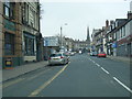
Rotherham - training centre on Main Street
Image: © Dave Bevis
Taken: 30 Mar 2014
0.03 miles
4
Rotherham Westgate railway station (site)
Opened in 1838 by the Sheffield and Rotherham Railway, later part of the Midland Railway, this was the first station in Rotherham. It closed to passengers in 1952. The site was eventually redeveloped and was a sorting office when this image was taken from Westgate.
Image: © Nigel Thompson
Taken: 7 Feb 2009
0.03 miles
5
Alma Tavern, Rotherham
The long-closed, Alma Tavern, Westgate, Rotherham.
Image: © Dave Pickersgill
Taken: 22 Mar 2016
0.03 miles
7
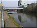
Rotherham - Corporation Bridge
Photo taken from Don Street. Left to right can be seen:
The Don Navigation towpath.
The single-span Corporation Bridge carries Main Street over the Don Navigation.
Just beyond the bridge, the waterway splits into two. The left branch is the navigable Rotherham Cut and the right branch leads to a weir on the River Don. Between the two branches is Forge Island, currently home to TESCO.
The multi-storey building is the Keppel Wharf office block.
The spire of Rotherham Minster can just be seen on the right-hand skyline.
Image: © Dave Bevis
Taken: 30 Mar 2014
0.05 miles
8
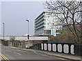
Rotherham - Don Street and Corporation Bridge
For a more complete photo of Corporation Bridge, please see Image
The black-and-white bridge parapet seen in the bottom right-hand quadrant of the photo is a bit of a puzzle. The design suggests that this Don Street bridge was built in the canal-building era. However, I am unsure whether it was an access to a wharf to the west of the Don Navigation or actually part of the Don Navigation prior to 1838. In 1838, the Don Navigation was diverted to make way for the building of the railway from Sheffield to Rotherham Westgate Station. The Wikipedia article at http://en.wikipedia.org/wiki/Rotherham_Westgate_railway_station provides a few clues but not a definitive answer.
Image: © Dave Bevis
Taken: 30 Mar 2014
0.05 miles
9
Rotherham pubs
Now the Get Sorted Academy of Music, this former pub situated at the corner of Westgate and Wilfred Street was the Wellington Inn, and was built in 1903.
Image: © Bobby Clegg
Taken: 18 Oct 2008
0.05 miles
10
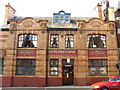
Rotherham pubs
This is a facade view of The Cutlers' Arms on Westgate which was built in 1900, replacing an earlier house.
Image: © Bobby Clegg
Taken: 18 Oct 2008
0.05 miles