IMAGES TAKEN NEAR TO
Basil Close, CHESTERFIELD, S41 7SL
Introduction
This page details the photographs taken nearby to Basil Close, S41 7SL by members of the Geograph project.
The Geograph project started in 2005 with the aim of publishing, organising and preserving representative images for every square kilometre of Great Britain, Ireland and the Isle of Man.

There are currently over 7.5m images from over14,400 individuals and you can help contribute to the project by visiting https://www.geograph.org.uk
Image Map
Images are licensed for reuse under creativecommons.org/licenses/by-sa/2.0
Notes
- Clicking on the map will re-center to the selected point.
- The higher the marker number, the further away the image location is from the centre of the postcode.
Image Listing (463 Images Found)
Images are licensed for reuse under creativecommons.org/licenses/by-sa/2.0
Image
Details
Distance
1
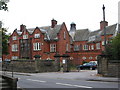
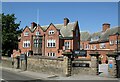
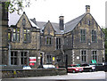
Chesterfield - St Helena's
Former grammar school, now administrative offices for Derbyshire County Council.
Image: © Dave Bevis
Taken: 14 Oct 2010
0.01 miles
2
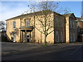
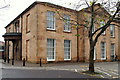
Chesterfield - Holywell House
On Holywell Street. This was part of Chesterfield Royal Hospital (doctors lodgings) before it re-located to Calow.
Image: © Dave Bevis
Taken: 15 Nov 2009
0.01 miles
3
Former Saint Helena School, Chesterfield
Built in 1911, architect George Widdows, Listed Grade II. Now part of the University of Derby. One of the four schoolroom wings.
Image: © Alan Murray-Rust
Taken: 15 Jun 2021
0.02 miles
4
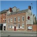
1 Sheffield Road, Chesterfield
A fine Georgian survivor, from the 18th century, now in use as business premises, Listed Grade II.
Image: © Alan Murray-Rust
Taken: 15 Jun 2021
0.04 miles
5
Former Saint Helena School, Chesterfield
Built in 1911, architect George Widdows, Listed Grade II. Now part of the University of Derby. This was originally the administration block.
Image: © Alan Murray-Rust
Taken: 15 Jun 2021
0.04 miles
6
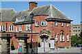
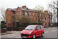
Holywell Street, Chesterfield, Derbys.
The main facades of Holywell House face south-east and north-east onto a large car parking area. Holywell Street is just visible behind the railings beyond the porch. This Grade II-listed early C19th building is currently an annexe belonging to Holywell Healthcare, a GP medical practice with other local surgeries. It was reopened by the Duchess of Devonshire in 1993 following renovations. As it is adjacent to the former Royal Hospital site it may have been an annexe to that in the past?
Image: © David Hallam-Jones
Taken: 22 Nov 2014
0.04 miles
7
Holywell House, Holywell Street, Chesterfield
Early 19th century house, brick with ashlar main front, latterly part of the local hospital, currently a veterinary centre. Listed Grade II.
Image: © Alan Murray-Rust
Taken: 15 Jun 2021
0.04 miles
9
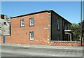
Chesterfield - College (West Block)
On Sheffield Road.
Image: © Dave Bevis
Taken: 14 Oct 2010
0.06 miles
10
Holywell Street, Chesterfield, Derbys.
The former Royal Hospital (1859-1984/6), that now houses offices, faces the large Holywell Cross car park encompassed by various roads (hence it is sometimes referred to as "The Doughnut Roundabout"). The new Chesterfield & North Derbyshire Royal Hospital in Calow opened in April 1984. In 1986 building work began on a maternity and gynaecology unit on the Calow site and its opening in 1989 led to the final facilities in the town centre being closed. In 1984, the hospital was purchased by an orthopaedic surgeon who converted the lower portion of the hospital, adjoining Infirmary Road and Durrant Road, into the Alexandra Private Hospital. This seems to have functioned until the early 1990s.
Image: © David Hallam-Jones
Taken: 22 Nov 2014
0.06 miles