IMAGES TAKEN NEAR TO
Basin Square, Brimington Road, S41 7FH
Introduction
This page details the photographs taken nearby to Basin Square, Brimington Road, S41 7FH by members of the Geograph project.
The Geograph project started in 2005 with the aim of publishing, organising and preserving representative images for every square kilometre of Great Britain, Ireland and the Isle of Man.

There are currently over 7.5m images from over14,400 individuals and you can help contribute to the project by visiting https://www.geograph.org.uk
Image Map
Images are licensed for reuse under creativecommons.org/licenses/by-sa/2.0
Notes
- Clicking on the map will re-center to the selected point.
- The higher the marker number, the further away the image location is from the centre of the postcode.
Image Listing (469 Images Found)
Images are licensed for reuse under creativecommons.org/licenses/by-sa/2.0
Image
Details
Distance
1
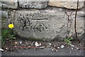
Benchmark on wall of Brimington Road
Ordnance Survey cut mark benchmark described on the Bench Mark Database at http://www.bench-marks.org.uk/bm70483
Image: © Roger Templeman
Taken: 1 Sep 2015
0.01 miles
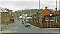
2
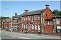
Former probation office, Brimington Road
Currently unoccupied, awaiting redevelopment as part of the Chesterfield Waterside development.
Image: © Alan Murray-Rust
Taken: 15 Jun 2021
0.01 miles
3
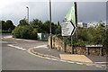
Junction of Brimington Road and Brewery Street
There is an OS benchmark Image on a stone at the base of the wall between the legs of the Brimington Road name sign
Image: © Roger Templeman
Taken: 1 Sep 2015
0.02 miles
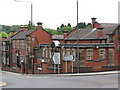
4
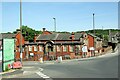
Former courts building, Brimington Road
Possibly originally juvenile court, later magistrates' court and latterly a martial arts centre. Awaiting redevelopment as part of the Chesterfield Waterside development.
Image: © Alan Murray-Rust
Taken: 15 Jun 2021
0.02 miles
5
Site of Chesterfield Central station, along Brimington Road from Malkin Street, 1989
The view is northward and the entrance to the ex-Great Central Railway Central station had been off on the left: the 'Station' sign is for the only remaining Chesterfield station - the former Midland station. Since this photograph was taken a new trunk A61 road has been constructed (off to the left here) partly along the course of the ex-GC Chesterfield Loop of the GC main line between Nottingham and Sheffield. The Loop and its stations were closed effectively from 4/3/63, but goods continued to be dealt with at Chesterfield Central until 11/9/67.
Image: © Ben Brooksbank
Taken: 23 Mar 1989
0.02 miles
6
Chesterfield - Brimington Road Court House
No longer a court house as such, but converted to a martial arts centre and Probation Service offices.
Image: © Dave Bevis
Taken: 10 May 2009
0.03 miles
7
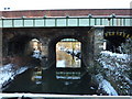
Rail bridge over Chesterfield Canal
At Crow Lane, near the station
Image: © Peter Barr
Taken: 7 Jan 2010
0.03 miles
8
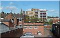
Between the station and the college, Chesterfield
A small industrial yard by Crow Lane near the station and the river, with Chesterfield College in the background.
Image: © Andrew Hill
Taken: 30 Apr 2012
0.04 miles

