IMAGES TAKEN NEAR TO
Ronksley, HOPE VALLEY, S33 0BB
Introduction
This page details the photographs taken nearby to Ronksley, S33 0BB by members of the Geograph project.
The Geograph project started in 2005 with the aim of publishing, organising and preserving representative images for every square kilometre of Great Britain, Ireland and the Isle of Man.

There are currently over 7.5m images from over14,400 individuals and you can help contribute to the project by visiting https://www.geograph.org.uk
Image Map
Images are licensed for reuse under creativecommons.org/licenses/by-sa/2.0
Notes
- Clicking on the map will re-center to the selected point.
- The higher the marker number, the further away the image location is from the centre of the postcode.
Image Listing (33 Images Found)
Images are licensed for reuse under creativecommons.org/licenses/by-sa/2.0
Image
Details
Distance
1
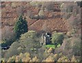
Birchinlee House viewed from Abbey Bank
Image: © Neil Theasby
Taken: 12 Nov 2015
0.01 miles
2
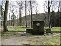
Remains of Tintown
Street and terraces on which stood the village of Birchinlee ('Tin Town'), home to many of the navvies that built the Derwent Valley dams. The corrugated iron buildings were sold off once the dams were complete, though part of one is still to be seen in the nearby village of Hope Image See also http://www.peakdistrict-nationalpark.info/time/derwent/tinTown.html
Image: © Giles Robinson
Taken: 2 Apr 2004
0.09 miles
3
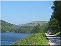
Cyclists at Derwent Reservoir
The paved path along the east bank of Derwent Reservoir is popular with cyclists. This view shows the island and Howden Dam in the distance, with a minor peak on Howden Moor on the skyline
Image: © Espresso Addict
Taken: 10 Jun 2006
0.09 miles
4
Upper Derwent Valley above Birchinlee
Image: © Chris Wimbush
Taken: 19 Apr 2009
0.11 miles
5
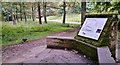
Birchinlee - explanation panel
Explaining the background and site plan of the temporary village of Birchinlee that existed for about 15 years during the construction of the two Upper Derwent dams 100 years ago.
Image: © Chris Morgan
Taken: 3 Sep 2014
0.12 miles
7
Welcome to (Tin Town) Birchinlee
The village of Birchinlee became better known as Tin Town, because of the corrugated iron used for the outside walls and roofs of the buildings. For 10 years it was home to between 600 and 1000 people including navvies, their families, shop keepers, a school teacher, missioner, doctor and policeman. The village was dismantled when the dams were completed, and today little remains of its existence.
Image: © Alan Heardman
Taken: 19 Mar 2008
0.12 miles
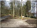
8
Derwent Reservoir - Birchinlee Village Marker
Birchinlee village was built by the Derwent Valley Water Board to accommodate navvies who built the Derwent and Howden Dams during the early part of the 20th century.
Image: © Alan Heardman
Taken: 19 Mar 2008
0.14 miles
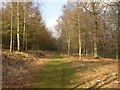
9
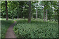
Path through Birchinlee East Plantation
The nettles and mounds suggest former habitation, and this was probably part of the former village of Birchinlee.
Image: © Bill Boaden
Taken: 19 Jul 2021
0.14 miles
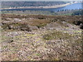
10
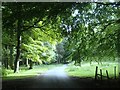
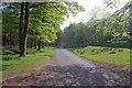
Lane through trees
The ground around upper Derwent reservoirs is largely wooded.
Image: © Andrew Hill
Taken: 25 Jul 2013
0.15 miles