IMAGES TAKEN NEAR TO
Spinkhill Lane, SHEFFIELD, S21 3YG
Introduction
This page details the photographs taken nearby to Spinkhill Lane, S21 3YG by members of the Geograph project.
The Geograph project started in 2005 with the aim of publishing, organising and preserving representative images for every square kilometre of Great Britain, Ireland and the Isle of Man.

There are currently over 7.5m images from over14,400 individuals and you can help contribute to the project by visiting https://www.geograph.org.uk
Image Map
Images are licensed for reuse under creativecommons.org/licenses/by-sa/2.0
Notes
- Clicking on the map will re-center to the selected point.
- The higher the marker number, the further away the image location is from the centre of the postcode.
Image Listing (32 Images Found)
Images are licensed for reuse under creativecommons.org/licenses/by-sa/2.0
Image
Details
Distance
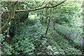
1
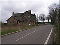
No bridge now at Bridge House
The Cuckoo Way crosses the road here, as once did the canal
Image: © John Slater
Taken: 14 Apr 2012
0.01 miles
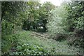
2
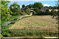
View to Bridge House and Spinkhill Lane
From the Transpennine Trail
Image: © Neil Theasby
Taken: 4 Oct 2012
0.02 miles
3
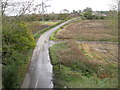
Spinkhill Lane - View from the Trans Pennine Trail
Image: © Alan Heardman
Taken: 28 Oct 2008
0.02 miles
4
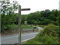
Spinkhill Lane towards the old railway bridge
View west from where the Cuckoo Way path crosses the lane.
Image: © Andrew Hill
Taken: 26 May 2011
0.05 miles
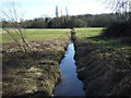
5
Chesterfield Canal and Trans Pennine Trail
Picture Image] looks towards the bridge I'm stood on here. From here, you can clearly see the cut of the disused Chesterfield Canal and, to the right, the path of the old GC (MS&LR) railway between Killamarsh and Renishaw. Planning permission has recently been posted (mid 2006) to try to rewater the canal almost up to this point from Renishaw. Up ahead, the canal turns to the south-west, and when built, didn't go under the bridge, but continued on a north-east line following the contour of the hill. It was diverted when the railway was built. Ironic really that the canal may yet end up back in full working condition whereas the railway will now be nothing more than a cycle and leisure trail.
Image: © David Morris
Taken: 27 May 2006
0.10 miles
6
Chesterfield Canal, Renishaw
According to old maps, this is where the original route and the current route parted company. In front, you can just make out one of the bridges built to get what's now a bridle path across the combined width of the railway and new cut.
The original path goes off to the north-west, hugging the 55m contour line and rejoins the original path in Image I assume the 'new cut' was done by the railway builders, looking at the bridges and cutting. I don't know the date, but it's certainly prior to 1907 because the 1907 OS map shows the new cut.
Image: © David Morris
Taken: 20 May 2006
0.10 miles
8
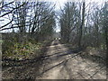
Trans Pennine Trail near Renishaw
Heading south on a disused railway.
Image: © JThomas
Taken: 7 Mar 2015
0.13 miles
9
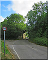
Renishaw: former railway bridge on Spinkhill Lane
A 40mph limit seems generous as the bridge is narrow by modern standards and on an almost blind dogleg. The bridge once carried the Great Central main line from Sheffield Victoria (left) to London Marylebone via Nottingham Victoria and Leicester Central. It now carries a cycle track (shown in Image]).
Image: © John Sutton
Taken: 21 Aug 2022
0.13 miles
10
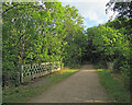
Renishaw: once a railway bridge
Now a cycle track and part of the Trans-Pennine Trail, this was once the trackbed of the Great Central Railway main line from London Marylebone to Sheffield Victoria (ahead) and Manchester. Iron trellis-pattern bridge parapets were a Great Central speciality - Image] shows one further south, near Nottingham. Image] shows this bridge from road level.
Image: © John Sutton
Taken: 21 Aug 2022
0.13 miles