IMAGES TAKEN NEAR TO
Standall Close, DRONFIELD, S18 8AB
Introduction
This page details the photographs taken nearby to Standall Close, S18 8AB by members of the Geograph project.
The Geograph project started in 2005 with the aim of publishing, organising and preserving representative images for every square kilometre of Great Britain, Ireland and the Isle of Man.

There are currently over 7.5m images from over14,400 individuals and you can help contribute to the project by visiting https://www.geograph.org.uk
Image Map
Images are licensed for reuse under creativecommons.org/licenses/by-sa/2.0
Notes
- Clicking on the map will re-center to the selected point.
- The higher the marker number, the further away the image location is from the centre of the postcode.
Image Listing (19 Images Found)
Images are licensed for reuse under creativecommons.org/licenses/by-sa/2.0
Image
Details
Distance
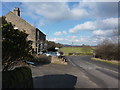
1
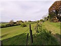
Track from Dunston Farm
Over Rod Moor, houses at Mickley on horizon.
Image: © Chris Morgan
Taken: 23 Apr 2020
0.05 miles
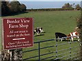
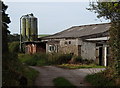
3
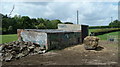
Fields and farm shed by Rod Moor Road
A small outbuilding in the fields by the road between Dronfield Moorhouse and Bradway.
Image: © Andrew Hill
Taken: 24 May 2011
0.11 miles
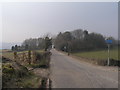
6
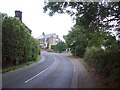
Junction of Rod Moor Road and Mickley Lane
Beyond the sharp bend ahead Rod Moor Road becomes Northern Common.
Image: © Jonathan Clitheroe
Taken: 1 Aug 2011
0.12 miles
7
Mickley - Rod Moor Road
Approaching junction with Mickley Lane.
Image: © Alan Heardman
Taken: 25 Aug 2009
0.13 miles
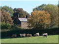
8
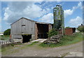
Farm buildings near Mickley
Seen from the footpath forming part of the Sheffield Country Walk.
Image: © Andrew Hill
Taken: 24 May 2011
0.13 miles
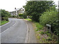
9
Northern Common becomes Rod Moor Road
At the junction, Rod Moor on the right, and Mickley Lane on the left
Image: © Peter Barr
Taken: 20 Feb 2010
0.14 miles
10
Track and farm outbuildings, Mickley
The path to Fanshawe Gate Lane passes by the farm buildings.
Image: © Andrew Hill
Taken: 6 Sep 2012
0.15 miles