IMAGES TAKEN NEAR TO
Baslow Road, SHEFFIELD, S17 4DT
Introduction
This page details the photographs taken nearby to Baslow Road, S17 4DT by members of the Geograph project.
The Geograph project started in 2005 with the aim of publishing, organising and preserving representative images for every square kilometre of Great Britain, Ireland and the Isle of Man.

There are currently over 7.5m images from over14,400 individuals and you can help contribute to the project by visiting https://www.geograph.org.uk
Image Map
Images are licensed for reuse under creativecommons.org/licenses/by-sa/2.0
Notes
- Clicking on the map will re-center to the selected point.
- The higher the marker number, the further away the image location is from the centre of the postcode.
Image Listing (29 Images Found)
Images are licensed for reuse under creativecommons.org/licenses/by-sa/2.0
Image
Details
Distance
1
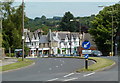
A621 Baslow Road, Totley
The start of a dual carriageway section through New Totley, looking in the direction of Sheffield.
Image: © Andrew Hill
Taken: 24 Jul 2011
0.01 miles
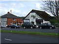
2
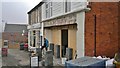
S H Wesley & Son Ltd, Baslow Road, Totley - rising from the dead!
Mellows cafe has recently been refurbished, not very long after the previous owners had expanded into the shop next door. Clearly that didn't work, so now the much earlier sign of S H Wesley, newsagent, tobacconist, stationer, and confectioners is revealed as the original two shops are recreated.
The company was voluntarily wound up on 22nd October 1968.
Image: © Chris Morgan
Taken: 5 Mar 2013
0.01 miles
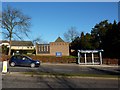
3
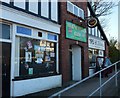
Totley Library, Baslow Road
A reviewer once said of the library "This library is ok, but it is very small and worn around the edges. The odd design of the building is interesting, and some of the staff are nice.
The childrens section is alright for little ones to play in, it has toys and a nice crawling and sitting space. They also put on some good events for children and offer colouring facilities."
I wonder what they might have said about the library's predecessor at Image?
Image: © Peter Barr
Taken: 30 Jan 2010
0.02 miles
4
Conservative Club and hairdresser, Totley
Image: © Peter Barr
Taken: 30 Jan 2010
0.02 miles
6
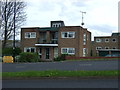
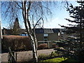
Block of flats, New Totley
Off Baslow Road.
Image: © JThomas
Taken: 26 Apr 2014
0.02 miles
8
The Chapel of the English Martyrs, Baslow Road
Image: © Peter Barr
Taken: 30 Jan 2010
0.05 miles
9
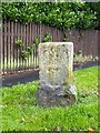
Old Boundary Marker
Parish Boundary Marker on the southwest side of the junction of Mickley Lane and Baslow Road, Sheffield. Inscribed A St J C / 1877 (Abbeydale St John Consolidated Chapelry). This stone originally said "A St J C C / 1877" with a number. This stands for Abbeydale St John Consolidated Chapelry. This appears to be No 2: there were six of them originally, and it would be interesting to know if any others have survived or been swallowed up in later housing developments. Full details of the boundary and locations of the others are in the London Gazette of 25 January 1878, pages 391-392. See https://www.thegazette.co.uk/London/issue/24546/page/391. Information from Richard Heywood. See also https://www.geograph.org.uk/photo/6110723.
Milestone Society National ID: YW_SHStJ01pb
Image: © C Brash
Taken: 30 Jun 2020
0.05 miles
10
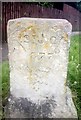
St John?s parish boundary marker
At the top of Mickley Lane where it joins Baslow Road, Totley
Image: © Karen Turner
Taken: 2 Jul 2016
0.05 miles