IMAGES TAKEN NEAR TO
Malpas Road, DAGENHAM, RM9 5SD
Introduction
This page details the photographs taken nearby to Malpas Road, RM9 5SD by members of the Geograph project.
The Geograph project started in 2005 with the aim of publishing, organising and preserving representative images for every square kilometre of Great Britain, Ireland and the Isle of Man.

There are currently over 7.5m images from over14,400 individuals and you can help contribute to the project by visiting https://www.geograph.org.uk
Image Map
Images are licensed for reuse under creativecommons.org/licenses/by-sa/2.0
Notes
- Clicking on the map will re-center to the selected point.
- The higher the marker number, the further away the image location is from the centre of the postcode.
Image Listing (62 Images Found)
Images are licensed for reuse under creativecommons.org/licenses/by-sa/2.0
Image
Details
Distance
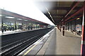
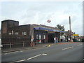
2
Becontree from the air
Becontree railway station is in the foreground, with Parsloes Park on the right. Roding Primart School https://www.rodingprimaryschool.co.uk/ is prominent in the centre.
Image: © Thomas Nugent
Taken: 26 Aug 2019
0.07 miles
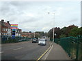
4
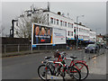
Gale Street, Becontree
Looking south along Gale Street from outside the entrance to Becontree Underground Station. The billboards advertise Now TV and mortgages from the Nationwide Building Society. The parade of shops was built to provide local services to the vast surrounding former London County Council housing estate.
Image: © Stephen McKay
Taken: 13 Feb 2020
0.08 miles
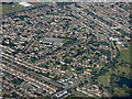
6
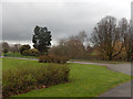
Parsloes Park
When the London County Council built Becontree housing estate between 1921 and 1935 it made generous provision for a public park which was eventually opened as Parsloes Park in 1935. The name derives from a 13th century family, recorded as Passelewe, who owned land in the area. It is now managed by Barking and Dagenham Borough Council.
Image: © Stephen McKay
Taken: 13 Feb 2020
0.09 miles
7
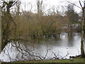
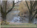
Parsloes Park lake
Parsloes Park lies on the site of Parsloes Manor, named after Hugh Passelewe, a 13th century owner. In 1619 the manor passed to the Fanshawe family, who owned it for 300 years until it was sold to the London County Council at the time of the First World War. The house which had fallen into disrepair was demolished in 1925 but the park was kept as open space for the residents of Becontree Estate, then under construction. It was opened as a public open space in 1935 to celebrate the official completion of the estate.
Image: © Marathon
Taken: 9 Mar 2016
0.10 miles
8
Parsloes Park
Showing the pond in this 143 acre (58 hectare) park. Parsloes Park serves as a facility for the Becontree Estate and is managed by Barking and Dagenham Council.
Image: © Stephen McKay
Taken: 13 Feb 2020
0.10 miles
9
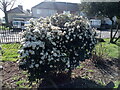
View of a flowery bush in Parsloes Park
Looking south-southwest.
Image: © Robert Lamb
Taken: 19 Mar 2021
0.10 miles