IMAGES TAKEN NEAR TO
Valence Avenue, DAGENHAM, RM8 3QU
Introduction
This page details the photographs taken nearby to Valence Avenue, RM8 3QU by members of the Geograph project.
The Geograph project started in 2005 with the aim of publishing, organising and preserving representative images for every square kilometre of Great Britain, Ireland and the Isle of Man.

There are currently over 7.5m images from over14,400 individuals and you can help contribute to the project by visiting https://www.geograph.org.uk
Image Map
Images are licensed for reuse under creativecommons.org/licenses/by-sa/2.0
Notes
- Clicking on the map will re-center to the selected point.
- The higher the marker number, the further away the image location is from the centre of the postcode.
Image Listing (22 Images Found)
Images are licensed for reuse under creativecommons.org/licenses/by-sa/2.0
Image
Details
Distance
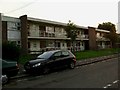
1
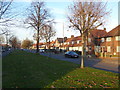
Valence Avenue, Becontree Estate
The London County Council decided to build the Becontree Estate to house many of the people from the East End of London displaced by slum clearance schemes. Barking and Dagenham, being almost flat and well-drained, offered an ideal site. Between 1920 and 1922 the LCC acquired 3,000 acres of land in Barking and Dagenham, as well as adjoining parts of Ilford, using compulsory purchase powers. Building started almost straight away, at first centred near Goodmayes and Chadwell Heath, and from 1923 around Dagenham Village. These centres soon joined up, and building continued until 1934. By 1932 the population had grown to 103,328 from 2,086 in 1922.
Before development took place, most traces of the former landscape were obliterated. All the former farmhouses were demolished with the sole exception of Valence House which was saved when it was purchased from the LCC in 1926 by Dagenham Urban District Council. The landscape was largely devoid of trees and so it is difficult to find any tree within the Becontree Estate which pre-dates the development, other than those in the grounds of Valence House and Parsloes Park.
There was a new layout of geometrically designed roads, sometimes with central reservations as here in Valence Avenue. Some of the pre-existing roads such as Wood Lane and Bennett's Castle Lane were retained, but others such as Gale Street and Broad Street were rerouted or lost.
Image: © Marathon
Taken: 30 Nov 2016
0.06 miles
2
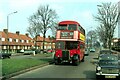
RT624 on Valance Avenue, Dagenham ? 7 April 1979
This was the very last normal service journey by the iconic London Transport RT Type.
The RT was introduced in 1938 and was the epitome of the standard red London bus. The last examples were built in 1954, so those that lasted to the end were at least 25 years old, an unusual longevity with a single operator.
This particular vehicle, RT624, was actually built in 1948, although with the London Transport overhaul regime it is difficult to know exactly what of the original bus was represented 30 years later. As befits its historic status as the last of its kind in service, it has been preserved, currently (2022) by Ensign Bus, where it is available for hire.
Image: © Alan Murray-Rust
Taken: 7 Apr 1979
0.06 miles
3
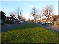
Valence Avenue, Becontree Estate
The London County Council decided to build the Becontree Estate to house many of the people from the East End of London displaced by slum clearance schemes. Barking and Dagenham, being almost flat and well-drained, offered an ideal site. Between 1920 and 1922 the LCC acquired 3,000 acres of land in Barking and Dagenham, as well as adjoining parts of Ilford, using compulsory purchase powers. Building started almost straight away, at first centred near Goodmayes and Chadwell Heath, and from 1923 around Dagenham Village. These centres soon joined up, and building continued until 1934. By 1932 the population had grown to 103,328 from 2,086 in 1922.
Before development took place, most traces of the former landscape were obliterated. All the former farmhouses were demolished with the sole exception of Valence House which was saved when it was purchased from the LCC in 1926 by Dagenham Urban District Council. The landscape was largely devoid of trees and so it is difficult to find any tree within the Becontree Estate which pre-dates the development, other than those in the grounds of Valence House and Parsloes Park.
There was a new layout of geometrically designed roads, sometimes with central reservations as here in Valence Avenue. Some of the pre-existing roads such as Wood Lane and Bennett's Castle Lane were retained, but others such as Gale Street and Broad Street were rerouted or lost.
Image: © Marathon
Taken: 30 Nov 2016
0.07 miles
5
Flats in Seabrooke Rd
Flats of this vintage are not common on the Becontree Estate as it was mostly constructed between the world wars. TQ4786 has just about the least green space of any grid square on the estate it being almost equidistant from Valance Park in the East and Goodmayes park in the West
Image: © Glyn Baker
Taken: 22 Sep 2005
0.12 miles
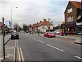
6
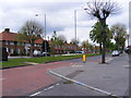
Valence Avenue, Becontree
At the junction with Lindisfarne Road
Image: © Geographer
Taken: 4 May 2010
0.13 miles
7
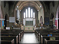
St Thomas, Haydon Road, Becontree - East end
Image: © John Salmon
Taken: 19 Feb 2005
0.15 miles
8
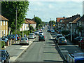
Bonham Road, Becontree
Viewed from the top end on Green Lane.
Image: © Robin Webster
Taken: 25 Jun 2011
0.15 miles
9
Valance House Becontree
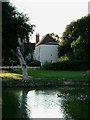
This is Valance House Becontree. It is the last survivor of Dagenham’s five manor houses. It was preserved as the estate management offices during the construction of the huge Becontree Council Housing Estate before WW2. Valance House was named after Agnes De Valance who lived and was murdered on the site in the 13th Century. Some say her ghost still haunts the grounds. Parts of the current house date from the 15th Century although from its outward appearance one would be hard pushed to guess which. In 1938 one room of the building was opened as a museum, a function the whole building fulfils today. The picture was taken looking across the moat towards the house.
Image: © Glyn Baker
Taken: 7 Sep 2005
0.17 miles
10
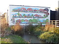
Mural in Valence Park
Valence House is one of the few original buildings to have survived the construction of the Becontree Estate. The present building is a moated 17th century manor house, once the most important house in Barking & Dagenham, and is now the only surviving of the five manor houses of Dagenham. The timber framed museum building, partially surrounded by a moat, is situated in Valence Park and now houses a museum. The museum contains permanent exhibitions on history and life in Barking & Dagenham, and includes displays of the 1945 Becontree Estate.
The house and park to the south were purchased by the Borough in 1926 from the London County Council. The LCC had themselves acquired them as part of the Becontree Estate development.
The north and east parts of the moat survive. This mural is at the western end of a linear lake which is roughly where the southern arm would have been, but appears not to be original. See also http://www.geograph.org.uk/photo/5213364
More information about the house and its history can be found at https://en.wikipedia.org/wiki/Valence_House_Museum and for details of opening times and exhibitions see http://valencehousecollections.co.uk/
Image: © Marathon
Taken: 30 Nov 2016
0.18 miles