IMAGES TAKEN NEAR TO
Yew Tree Gardens, ROMFORD, RM7 9RA
Introduction
This page details the photographs taken nearby to Yew Tree Gardens, RM7 9RA by members of the Geograph project.
The Geograph project started in 2005 with the aim of publishing, organising and preserving representative images for every square kilometre of Great Britain, Ireland and the Isle of Man.

There are currently over 7.5m images from over14,400 individuals and you can help contribute to the project by visiting https://www.geograph.org.uk
Image Map
Images are licensed for reuse under creativecommons.org/licenses/by-sa/2.0
Notes
- Clicking on the map will re-center to the selected point.
- The higher the marker number, the further away the image location is from the centre of the postcode.
Image Listing (152 Images Found)
Images are licensed for reuse under creativecommons.org/licenses/by-sa/2.0
Image
Details
Distance
1
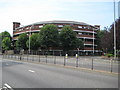
Romford: The Rotunda
Viewing this building on satellite imagery it looks like the old Wembley Stadium, but there is more than a hint that it is not quite symmetrical with the southern end wider than the northern. It is a residential block of flats and is viewed here looking across St Edwards Way, better known as the Romford Ring Road.
Image: © Nigel Cox
Taken: 27 Jul 2008
0.02 miles
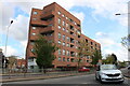
3
The Rotunda
An unusual block of flats in Romford
Image: © Glyn Baker
Taken: 3 Jul 2012
0.03 miles
4
View of Angel Way from St Edwards Way
This is the end of Angel Way alongside St Edwards Way (the Romford ring road). It is simply a small, narrow street that has parking facilities as well as leads traffic from the Angel Way multi-storey car park onto St Edwards Way at the roundabout where the latter road and North Street meet. View taken looking east-southeast towards the town centre. The multi-storey car park is out of shot to the right.
Image: © Robert Lamb
Taken: 10 Oct 2008
0.04 miles
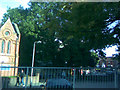
5
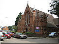
Romford: Trinity Methodist Church
This was an attempt to re-create a Francis Frith image from exactly 100 years ago http://www.francisfrith.com/search/england/essex/romford/photos/romford_59842.htm Unfortunately trees now obstruct the original view point and the Frith photograph was probably taken from a point which is now in the middle of the Romford Ring Road...
As my better half pointed out to me the major visible change in the church since the 1908 photograph was taken is the fact that the surprisingly flamboyant and slender Rapunzel-style towers on either side of the main gable end have been considerably shortened since 1908.
The foundation stone of the church was laid in 1887.
Image: © Nigel Cox
Taken: 27 Jul 2008
0.04 miles
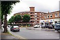
6
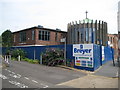
Auction Angels?
Romford Auction Rooms with Angel Street multi-storey car park above
Image: © Glyn Baker
Taken: 3 Jul 2012
0.04 miles
7

River Rom in Romford
The River Rom just clips across the north-east corner of this grid square as it goes under the Romford Ring Road, prior to entering a long culvert under the Brewery Development site. This is the view looking downstream from the ring road bridge with a rather attractive footbridge that allows pedestrian access between two car parks.
Image: © Nigel Cox
Taken: 27 Jul 2008
0.06 miles
8

River Rom in Romford
The River Rom just clips across the north-east corner of this grid square as it goes under the Romford Ring Road, prior to entering a long culvert under the Brewery Development site. This is the view looking upstream from the ring road bridge. The grey slab at the top of the photograph is the bottom of a maintenance access ramp.
Image: © Nigel Cox
Taken: 27 Jul 2008
0.06 miles
9
Romford: Salvation Army Citadel
The church in the High Street is currently closed while a major refurbishment is undertaken.
Image: © Nigel Cox
Taken: 27 Jul 2008
0.07 miles
10
High Street, Romford
Angel Way begins as High Street at its junction with St Edwards Way - it doesn't become Angel Way until you reach the road barrier on the High Street and you turn the corner to get into the multi-storey car park. View taken looking northeast towards the town centre from St Edwards Way.
Image: © Robert Lamb
Taken: 10 Oct 2008
0.07 miles