IMAGES TAKEN NEAR TO
Elwick Road, SOUTH OCKENDON, RM15 6ED
Introduction
This page details the photographs taken nearby to Elwick Road, RM15 6ED by members of the Geograph project.
The Geograph project started in 2005 with the aim of publishing, organising and preserving representative images for every square kilometre of Great Britain, Ireland and the Isle of Man.

There are currently over 7.5m images from over14,400 individuals and you can help contribute to the project by visiting https://www.geograph.org.uk
Image Map
Images are licensed for reuse under creativecommons.org/licenses/by-sa/2.0
Notes
- Clicking on the map will re-center to the selected point.
- The higher the marker number, the further away the image location is from the centre of the postcode.
Image Listing (12 Images Found)
Images are licensed for reuse under creativecommons.org/licenses/by-sa/2.0
Image
Details
Distance
1
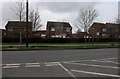
South Road, South Ockendon
From the entrance to Mardyke Golf Club
Image: © David Howard
Taken: 22 Feb 2020
0.10 miles
2
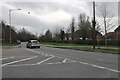
South Road, South Ockendon
At the entrance to Mardyke Golf Club
Image: © David Howard
Taken: 22 Feb 2020
0.10 miles
3
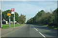
Elwick Road bus stop
On South Road, but named after the nearest side turning as is the usual practice. There is a 30 limit on this road.
Image: © Robin Webster
Taken: 15 Sep 2011
0.10 miles
4
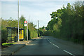
Stifford Road bus stop
Actually on South Road, but named after a side road as is the usual practice. Routes stopping are 11, 370 and X81. The 370 is a long-standing route, originally with green London Country buses running from Tilbury Ferry to Romford. It is now cut back to start at Lakeside.
Image: © Robin Webster
Taken: 15 Sep 2011
0.20 miles
5
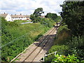
South Ockendon: railway
The single track railway line between Chafford Hundred and Ockendon stations viewed here from the Stifford Road overbridge.
Image: © Nigel Cox
Taken: 11 Aug 2006
0.21 miles
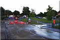
6
Cruick Avenue (After The Flood)
The aftermath of a burst water main in Stifford Rd
Image: © Glyn Baker
Taken: 20 Jun 2020
0.22 miles
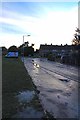
7
Muddy Footprints in Stifford Road
Mud left after the burst water main in Stifford Road
Image: © Glyn Baker
Taken: 20 Jun 2020
0.23 miles
8
Cruick Ave to Stifford Rd (After The Flood)
A postdiluvian shot showing the muck left after the burst water main in Stifford Road
Image: © Glyn Baker
Taken: 20 Jun 2020
0.23 miles
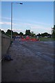
9
Aftermath of Burst Water Main in Stifford Rd
Taken looking towards Ford Place. Some houses in Image to the left and Image to the right were inundated with 2 nearly feet of water. Have a look in the Image
Image: © Glyn Baker
Taken: 20 Jun 2020
0.24 miles
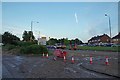
10
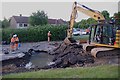
Big Hole in Stifford Road
The aftermath of a burst water main in Stifford Road.
Q: What is the difference between a flood caused by a cloudburst and one caused by Essex & Suffolk Water?
A: With a cloudburst sometimes you can prepare for it thanks to a weather forecast!
I have to admit the crisis team did seem to arrive fairly quickly. However I am lucky my house is far enough away to be dry.
Image: © Glyn Baker
Taken: 20 Jun 2020
0.24 miles