IMAGES TAKEN NEAR TO
Risebridge Chase, ROMFORD, RM1 4PR
Introduction
This page details the photographs taken nearby to Risebridge Chase, RM1 4PR by members of the Geograph project.
The Geograph project started in 2005 with the aim of publishing, organising and preserving representative images for every square kilometre of Great Britain, Ireland and the Isle of Man.

There are currently over 7.5m images from over14,400 individuals and you can help contribute to the project by visiting https://www.geograph.org.uk
Image Map (Loading...)


Getting Data...Please wait
Leaflet Map data © OpenStreetMap
Images are licensed for reuse under creativecommons.org/licenses/by-sa/2.0
Notes
- Clicking on the map will re-center to the selected point.
- The higher the marker number, the further away the image location is from the centre of the postcode.
Image Listing (9 Images Found)
Images are licensed for reuse under creativecommons.org/licenses/by-sa/2.0
Image
Details
Distance
1
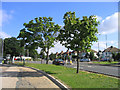
Havering Road, Collier Row, Romford, Essex
Looking north at junction of Lower Bedfords Road and Chase Cross Road.
Image: © John Winfield
Taken: 8 Aug 2005
0.15 miles
2
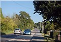
Lower Bedfords Road
At this point the road is passing between Rise Park to the right and Bedfords Park to the left.
Image: © Trevor Harris
Taken: 27 Sep 2009
0.16 miles
3
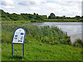
Main Lake, Bedfords Park
The information board tells us that it was created in the 1950s.
Image: © Robin Webster
Taken: 30 Jun 2012
0.21 miles
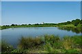
4
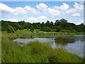
Bedfords Park Lake
The east end of the lake, which was not very popular with waterfowl despite the 'natural' lake margins. Just a few Coots were seen.
Image: © Robin Webster
Taken: 30 Jun 2012
0.21 miles
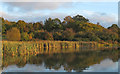
5
Bedfords Park Lake
The main lake in Bedfords Park it was dug by the Council in the 1950’s to provide a fishing pond. It used to be the rubbish dump for the “big house”. The tower block shows just how close the Park is to London’s fringe.
Image: © Glyn Baker
Taken: 24 May 2009
0.21 miles
6
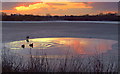
Sunset over Bedfords Park pond
The pond was almost iced over, save for the small pool at the eastern end, reflecting the sunset, beautifully.
Image: © Ian Dalgliesh
Taken: 5 Jan 2009
0.22 miles
7
View from Bedfords Lake, Bedfords Park, Havering-atte-Bower
Bedfords Park is managed by the Essex Wildlife Trust: http://www.essexwt.org.uk/reserves/bedfords-park
Image: © Roger Jones
Taken: 13 Nov 2016
0.23 miles
8
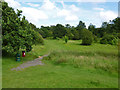
In Bedfords Park
A path across the stream feeding the lake.
Image: © Robin Webster
Taken: 30 Jun 2012
0.24 miles
9
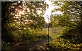
Path out of the copse, Bedfords Park, Havering-atte-Bower
Looking to the direction of Bedfords Lake.
Bedfords Park is managed by the Essex Wildlife Trust: http://www.essexwt.org.uk/reserves/bedfords-park
Image: © Roger Jones
Taken: 13 Nov 2016
0.24 miles