IMAGES TAKEN NEAR TO
Lower Bedfords Road, ROMFORD, RM1 4DG
Introduction
This page details the photographs taken nearby to Lower Bedfords Road, RM1 4DG by members of the Geograph project.
The Geograph project started in 2005 with the aim of publishing, organising and preserving representative images for every square kilometre of Great Britain, Ireland and the Isle of Man.

There are currently over 7.5m images from over14,400 individuals and you can help contribute to the project by visiting https://www.geograph.org.uk
Image Map (Loading...)


Getting Data...Please wait
Leaflet Map data © OpenStreetMap
Images are licensed for reuse under creativecommons.org/licenses/by-sa/2.0
Notes
- Clicking on the map will re-center to the selected point.
- The higher the marker number, the further away the image location is from the centre of the postcode.
Image Listing (11 Images Found)
Images are licensed for reuse under creativecommons.org/licenses/by-sa/2.0
Image
Details
Distance
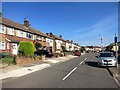
1
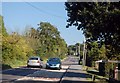
Lower Bedfords Road
At this point the road is passing between Rise Park to the right and Bedfords Park to the left.
Image: © Trevor Harris
Taken: 27 Sep 2009
0.03 miles
2
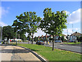
Havering Road, Collier Row, Romford, Essex
Looking north at junction of Lower Bedfords Road and Chase Cross Road.
Image: © John Winfield
Taken: 8 Aug 2005
0.06 miles
3
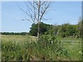
The edge of Bedfords Park
This view looks across Lower Bedford Road to the edge of Bedfords Park.
What is now Bedfords Park originated in the two adjoining estates of Bedfords, believed to be named after John Bedford, who held the land in 1362, and Earls, which later became known as Upper Bedfords. The lane which had run from Broxhill Road to Lower Bedfords Road and going past Bedfords was closed by the owner around 1777. This is still the main north-south route through the park although from Broxhill Road to the Visitor Centre it is a proper access road while to the south of this as far as Lower Bedfords Road it is no more than a path.
Bedfords was sold to Romford Urban District Council in 1933 who opened the park to the public in 1934, and instituted a museum in the house. During the Second World War Bedfords House was used by the Auxiliary Fire Service and afterwards was used as the Council archive but was gradually allowed to fall into disrepair until it was demolished in 1959. In the 1960s a cafe was built on the site of the house until this also fell out of use in the 1980s. The site of the house is now occupied by a Visitor Centre run by Essex Wildlife Trust.
For a fuller history see https://en.wikipedia.org/wiki/Bedfords_Park and for a list of the facilities see http://www.essexwt.org.uk/reserves/bedfords-park
Image: © Marathon
Taken: 14 Jun 2017
0.15 miles
4
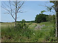
At Chase Cross
This view looks across Lower Bedford Road to the edge of Bedfords Park.
What is now Bedfords Park originated in the two adjoining estates of Bedfords, believed to be named after John Bedford, who held the land in 1362, and Earls, which later became known as Upper Bedfords. The lane which had run from Broxhill Road to Lower Bedfords Road and going past Bedfords was closed by the owner around 1777. This is still the main north-south route through the park although from Broxhill Road to the Visitor Centre it is a proper access road while to the south of this as far as Lower Bedfords Road it is no more than a path.
Bedfords was sold to Romford Urban District Council in 1933 who opened the park to the public in 1934, and instituted a museum in the house. During the Second World War Bedfords House was used by the Auxiliary Fire Service and afterwards was used as the Council archive but was gradually allowed to fall into disrepair until it was demolished in 1959. In the 1960s a cafe was built on the site of the house until this also fell out of use in the 1980s.
The site of the house is now occupied by a Visitor Centre run by Essex Wildlife Trust.
For a fuller history see https://en.wikipedia.org/wiki/Bedfords_Park and for a list of the facilities see http://www.essexwt.org.uk/reserves/bedfords-park
Image: © Marathon
Taken: 14 Jun 2017
0.15 miles
5
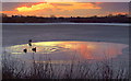
Sunset over Bedfords Park pond
The pond was almost iced over, save for the small pool at the eastern end, reflecting the sunset, beautifully.
Image: © Ian Dalgliesh
Taken: 5 Jan 2009
0.19 miles
6
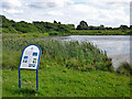
Main Lake, Bedfords Park
The information board tells us that it was created in the 1950s.
Image: © Robin Webster
Taken: 30 Jun 2012
0.21 miles
7
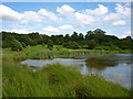
Bedfords Park Lake
The east end of the lake, which was not very popular with waterfowl despite the 'natural' lake margins. Just a few Coots were seen.
Image: © Robin Webster
Taken: 30 Jun 2012
0.22 miles
8
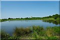
Bedfords Park Lake
The main lake in Bedfords Park it was dug by the Council in the 1950’s to provide a fishing pond. It used to be the rubbish dump for the “big house”. The tower block shows just how close the Park is to London’s fringe.
Image: © Glyn Baker
Taken: 24 May 2009
0.22 miles
10
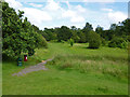
In Bedfords Park
A path across the stream feeding the lake.
Image: © Robin Webster
Taken: 30 Jun 2012
0.24 miles