IMAGES TAKEN NEAR TO
Central Way, OXTED, RH8 0LY
Introduction
This page details the photographs taken nearby to Central Way, RH8 0LY by members of the Geograph project.
The Geograph project started in 2005 with the aim of publishing, organising and preserving representative images for every square kilometre of Great Britain, Ireland and the Isle of Man.

There are currently over 7.5m images from over14,400 individuals and you can help contribute to the project by visiting https://www.geograph.org.uk
Image Map
Images are licensed for reuse under creativecommons.org/licenses/by-sa/2.0
Notes
- Clicking on the map will re-center to the selected point.
- The higher the marker number, the further away the image location is from the centre of the postcode.
Image Listing (21 Images Found)
Images are licensed for reuse under creativecommons.org/licenses/by-sa/2.0
Image
Details
Distance
1
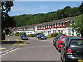
Silkham Road
A row of terraced houses on housing estate to north of Oxted.
Image: © Oast House Archive
Taken: 9 Jul 2010
0.12 miles
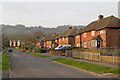
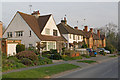
2
Westlands Way
Post war housing off Gordons Way. In the background is Oxted Quarry.
Image: © Ian Capper
Taken: 29 Mar 2011
0.16 miles
3
Central Way
Post war housing off Gordons Way. In the background are Oxted Downs on the North Downs.
Image: © Ian Capper
Taken: 29 Mar 2011
0.16 miles
4
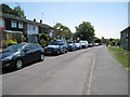
Silkham Road
A row of terraced houses on housing estate to north of Oxted.
Image: © Oast House Archive
Taken: 9 Jul 2010
0.17 miles
5
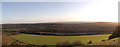
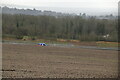
View of M25 from Oxted Downs
Looking down the National Trust owned and managed Oxted Downs towards Oxted and Limpsfield, the built up area in the background on the right. Running across the middle of the photo is the M25 motorway, crossed by a footbridge (on the far left) carrying a footpath linking Oxted with its eponymous Downs.
Image: © David Anstiss
Taken: 27 Nov 2011
0.18 miles
7
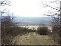
Vanguard Way down to the M25
Descending North Downs scarp slope on the Vanguard Way, facing S towards M25. GMT line is nearby.
Image: © Ibn Musa
Taken: 30 Mar 2013
0.19 miles
8
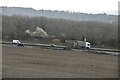
Chalkpit Lane
Houses in Chalkpit Lane. In the background on the right is the embankment of the London to East Grinstead/Uckfield railway.
Image: © Ian Capper
Taken: 29 Mar 2011
0.19 miles
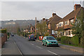
10
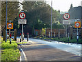
Entering Oxted
Traffic calming measures at the urban boundary on Chalkpit Lane.
Image: © Robin Webster
Taken: 18 Jan 2011
0.21 miles