IMAGES TAKEN NEAR TO
Vicarage Lane, HORLEY, RH6 8AR
Introduction
This page details the photographs taken nearby to Vicarage Lane, RH6 8AR by members of the Geograph project.
The Geograph project started in 2005 with the aim of publishing, organising and preserving representative images for every square kilometre of Great Britain, Ireland and the Isle of Man.

There are currently over 7.5m images from over14,400 individuals and you can help contribute to the project by visiting https://www.geograph.org.uk
Image Map
Images are licensed for reuse under creativecommons.org/licenses/by-sa/2.0
Notes
- Clicking on the map will re-center to the selected point.
- The higher the marker number, the further away the image location is from the centre of the postcode.
Image Listing (51 Images Found)
Images are licensed for reuse under creativecommons.org/licenses/by-sa/2.0
Image
Details
Distance
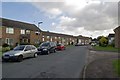
1
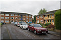
The Glebe
A close built in 1962 on the site of the former Horley Vicarage (hence Vicarage Lane, the road off which it comes off).
Image: © Ian Capper
Taken: 9 Oct 2011
0.03 miles
2
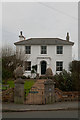
Chantry House
A locally listed house built in 1853 (according to Reigate and Banstead Borough Council's listed building list - recent estate agent sales particulars give a date of 1810).
Image: © Ian Capper
Taken: 8 Jan 2012
0.03 miles
3
The Glebe
A close built in 1962 on the site of the former Horley Vicarage (hence Vicarage Lane, the road in the foreground).
Image: © Ian Capper
Taken: 9 Oct 2011
0.04 miles
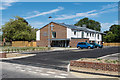
4
Chantry Close at the junction of Vicarage Lane
Image: © David Howard
Taken: 31 Jan 2016
0.07 miles
5
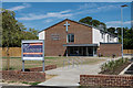
Horley Baptist Church
Horley Baptist Church in Court Lodge Road, seen here a week after its opening on 5 July 2015. It was built on part of the site of the former Court Lodge Infant and Nursery School (see Image), replacing a previous building in Brighton Road.
Image: © Ian Capper
Taken: 11 Jul 2015
0.08 miles
6
Horley Baptist Church
Horley Baptist Church in Court Lodge Road, seen here a week after its opening on 5 July 2015. It was built on part of the site of the former Court Lodge Infant and Nursery School (see Image), replacing a previous building in Brighton Road.
Image: © Ian Capper
Taken: 11 Jul 2015
0.09 miles
7
Chantry Close
A short close off Vicarage Lane, dating from 1956.
Image: © Ian Capper
Taken: 8 Jan 2012
0.09 miles
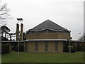
8
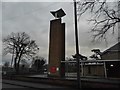
Bell tower at the Catholic Church of the English Martyrs
Image: © David Howard
Taken: 31 Jan 2016
0.09 miles
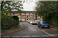
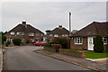
9
Court Lodge Road
Part of the Court Lodge Estate, built in 1965 for the then local council, Dorking and Horley RDC. The estate is named after Court Lodge Farm, which was situated next to the River Mole.
Image: © Ian Capper
Taken: 11 Sep 2011
0.09 miles
10
Church of the English Martyrs, Vicarage Lane, Horley.
This is the Roman Catholic Church in Horley
Image: © Richard Rogerson
Taken: 17 Feb 2009
0.09 miles