IMAGES TAKEN NEAR TO
Crabtree Lane, DORKING, RH5 6BQ
Introduction
This page details the photographs taken nearby to Crabtree Lane, RH5 6BQ by members of the Geograph project.
The Geograph project started in 2005 with the aim of publishing, organising and preserving representative images for every square kilometre of Great Britain, Ireland and the Isle of Man.

There are currently over 7.5m images from over14,400 individuals and you can help contribute to the project by visiting https://www.geograph.org.uk
Image Map
Images are licensed for reuse under creativecommons.org/licenses/by-sa/2.0
Notes
- Clicking on the map will re-center to the selected point.
- The higher the marker number, the further away the image location is from the centre of the postcode.
Image Listing (23 Images Found)
Images are licensed for reuse under creativecommons.org/licenses/by-sa/2.0
Image
Details
Distance
1
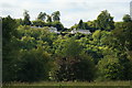
Houses Above Westhumble, Surrey
The houses nestle in a heavily wooded landscape.
Image: © Peter Trimming
Taken: 22 Sep 2009
0.04 miles
2
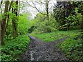
End of Six Mile Bottom
Six Mile Bottom, an informal (and misleading) name for the bridleway along the foot of Norbury Park, skirting the fields of Swanworth Farm, here seen just short of its southerly junction with Crabtree Lane and the south carriage drive to Norbury Park. To the right is a short cut across to the carriage drive and up Crabtree Lane towards Crabtree Lane car park.
Image: © Hugh Craddock
Taken: 5 May 2012
0.05 miles
3
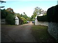
The entrance to Foxbury in Crabtree Lane
looking north-west
Image: © Andrew Longton
Taken: 20 Sep 2005
0.07 miles
4
Bridges over the River Mole
This footbridge carries the footpath over the old course of the River Mole (see Image). In the distance you can see the railway bridge and footbridge (see also Image) that cross the River Mole proper.
Image: © Martyn Davies
Taken: 14 Jan 2007
0.15 miles
5
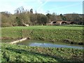
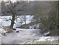
River Mole Meander
This is the old course of the River Mole, now only an oxbow lake connected to the river at one end. It's not marked on the modern OS Explorer or Landranger maps, but can clearly be seen on the 1873 map at http://www.old-maps.co.uk/ , and also shows up well on GoogleEarth.
Image: © Martyn Davies
Taken: 14 Jan 2007
0.15 miles
6
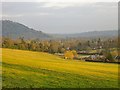
Sunlit downland pasture, Chapel Hill
Quite late on this overcast day the sun broke through, lighting up this hillside - though not for long. Down the slope, the nearest buildings are at Chapel Hill Farm. Across the Mole Valley, Box Hill has yet to catch the sun - and the area beyond, towards Gatwick, looks very gloomy.
Image: © Stefan Czapski
Taken: 17 Feb 2012
0.17 miles
7
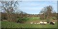
Sheep by the frozen Mole, Norbury Park
I saw very few sheep around Norbury Park on this bitterly cold day. These two trotted off as I approached, and huddled in the shelter of a thicket. This loop of old river-bed was once the course of the River Mole - the frozen body of water is an abandoned meander, a feature not as often seen on Geograph as might be expected. 'Abandoned' isn't quite the right word - left alone, I don't think the river would have left its old bed; most likely it was evicted by men with shovels, at some time in the last two hundred years.
The present course of the River Mole lies behind the camera, and the water was flowing fairly fast, following recent snow.
Image: © Stefan Czapski
Taken: 7 Feb 2012
0.22 miles
8
Towards Norbury Park
Looking towards Norbury Park (the white building on the skyline) from near Westhumble. The crescent of trees in the middle distance is a former meander of the River Mole.
Image: © Ian Capper
Taken: 3 May 2010
0.22 miles
9
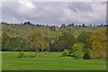
Towards Norbury Park
Norbury Park (the white building on the skyline) is a grade II* mansion built in 1774 by William Locke. For listing particulars see www.historicengland.org.uk/listing/the-list/list-entry/1228829.
Seen here from near Westhumble, with a former meander of the River Mole on the right.
Image: © Ian Capper
Taken: 3 May 2010
0.22 miles
10
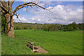
Chapel Hill
Water is a scarce resource on the chalk grasslands of the North Downs. The footpath up the hillside follows the fence.
Image: © Colin Smith
Taken: 22 May 2011
0.23 miles