IMAGES TAKEN NEAR TO
Beech Road, REIGATE, RH2 9LR
Introduction
This page details the photographs taken nearby to Beech Road, RH2 9LR by members of the Geograph project.
The Geograph project started in 2005 with the aim of publishing, organising and preserving representative images for every square kilometre of Great Britain, Ireland and the Isle of Man.

There are currently over 7.5m images from over14,400 individuals and you can help contribute to the project by visiting https://www.geograph.org.uk
Image Map
Images are licensed for reuse under creativecommons.org/licenses/by-sa/2.0
Notes
- Clicking on the map will re-center to the selected point.
- The higher the marker number, the further away the image location is from the centre of the postcode.
Image Listing (54 Images Found)
Images are licensed for reuse under creativecommons.org/licenses/by-sa/2.0
Image
Details
Distance
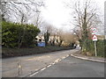
1
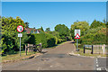
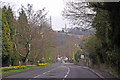
Brokes Road
Private road, regularly used as a cut through avoiding Reigate Hill, hence the narrowing here to control speed and the gate giving the facility to close the road to through traffic (although rarely, if ever, used). On the right is Beech Road, also private.
Image: © Ian Capper
Taken: 6 Jun 2020
0.10 miles
2
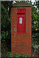
Edwardian postbox
With an OS benchmark in the pillar as an added bonus!
Image: © Ian Capper
Taken: 21 Apr 2008
0.11 miles
3
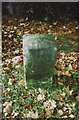
Old Milestone by the A217, London Road, Reigate Parish
Carved stone post by the A217, in parish of REIGATE (REIGATE AND BANSTEAD District), London Road, 100m South of junction with Raglan Road, on grass verge beside road and path, on West side of road. Lesser Surrey limestone pillar, erected by the Reigate turnpike trust in the 18th century.
Inscription reads:-
LONDON / 20 / - / SUTTON / 9 : : BRIGHTON / 31 / - / REIGATE / 1
Carved benchmark mid front face
Grade II Listed. List Entry Number: 1029062 https://historicengland.org.uk/listing/the-list/list-entry/1029062
Milestone Society National ID: SY_LQR20
Image: © L Joseph/J Payne
Taken: 1 Mar 2005
0.12 miles
4
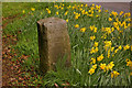
Milestone on Reigate Hill
Situated on the A217 north out of Reigate (see Image), this limestone milestone dates from the early 19th century and is Grade II listed. On the south face (visible) is written London 20, Sutton 9, and on the east face Brighton 31 5/8, Reigate 5/8.
Image: © Ian Capper
Taken: 15 Mar 2008
0.13 miles
5
Reigate Hill
Reigate Hill is the street name assigned to this section of the A217 out of Reigate leading up to Junction 8 of the M25. It is also the hill itself on the North Downs, as seen in the background with the television masts.
On the left can be seen an early 19th century milestone (see Image).
Image: © Ian Capper
Taken: 15 Mar 2008
0.13 miles
6
Pilgrims Way
This private road follows the route of the track that connected Reigate with the east-west pilgrims' route to Canterbury. However, despite the road name suggesting that it formed part of the main pilgrims' route, this has been refuted, although it was almost certainly used by those wanting to divert to civilisation (or refreshment!) in Reigate. It now forms part of the Millennium Trail, a pathway sponsored by Reigate and Banstead District Council, and which links with the track up Colley Hill (the hill in the background).
Above the lamp on the right can be seen the Reigate Hill TV transmitter.
Image: © Ian Capper
Taken: 2 Nov 2012
0.16 miles
7
Pilgrims Way
This private road follows the route of the track that connected Reigate with the east-west pilgrims' route to Canterbury. However, despite the road name suggesting that it formed part of the main pilgrims' route, this has been refuted, although it was almost certainly used by those wanting to divert to civilisation (or refreshment!) in Reigate. It now forms part of the Millennium Trail, a pathway sponsored by Reigate and Banstead District Council, and which links with the track up Colley Hill.
Image: © Ian Capper
Taken: 10 Oct 2010
0.16 miles
8
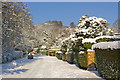
Pilgrims Way
This private road follows the route of the track that connected Reigate with the east-west pilgrims' route to Canterbury. However, despite the road name suggesting that it formed part of the main pilgrims' route, this has been refuted, although it was almost certainly used by those wanting to divert to civilisation (or refreshment!) in Reigate. It now forms part of the Millennium Trail, a pathway sponsored by Reigate and Banstead District Council, and which links with the track up Colley Hill (the hill in the background).
Shown here after what is reputed to be the heaviest snow in the area for 18 years.
Image: © Ian Capper
Taken: 7 Jan 2010
0.16 miles
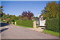
9
Reigate Hill at the junction of Raglan Road
Looking towards the Reigate Manor Hotel
Image: © David Howard
Taken: 29 Mar 2015
0.16 miles
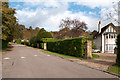
10
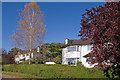
Brokes Road
A private road of 1930s(?) housing.
Image: © Ian Capper
Taken: 10 Oct 2010
0.16 miles