IMAGES TAKEN NEAR TO
Sussex Close, REIGATE, RH2 7DL
Introduction
This page details the photographs taken nearby to Sussex Close, RH2 7DL by members of the Geograph project.
The Geograph project started in 2005 with the aim of publishing, organising and preserving representative images for every square kilometre of Great Britain, Ireland and the Isle of Man.

There are currently over 7.5m images from over14,400 individuals and you can help contribute to the project by visiting https://www.geograph.org.uk
Image Map
Images are licensed for reuse under creativecommons.org/licenses/by-sa/2.0
Notes
- Clicking on the map will re-center to the selected point.
- The higher the marker number, the further away the image location is from the centre of the postcode.
Image Listing (68 Images Found)
Images are licensed for reuse under creativecommons.org/licenses/by-sa/2.0
Image
Details
Distance
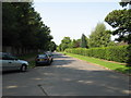
1
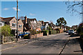
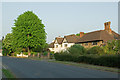
Oak Way
Development of this road started in the 1930s, like much of the area below the High Trees ridge.
Image: © Ian Capper
Taken: 1 Apr 2012
0.04 miles
2
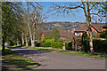
Ringley Park Avenue
A road of large houses leading up to the High Trees ridge. It originally served as an access route to the Waterlow family's house, High Trees (see Image). Housing development started in the 1930s. In the background is Reigate Hill, topped by its TV transmitter.
Image: © Ian Capper
Taken: 1 Apr 2012
0.09 miles
3
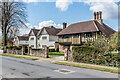
The Chase
A road marked on 19th and early 20th Century maps as Chart Road, but with no development, part of a line of paths and roads connecting Cockshot Hill and Shaws Corner. The current name first appears on the 1935 1:2,500 map, along with a few houses, including no 9, the nearest of the houses seen here. The further ones are not marked and so would seem to be slightly later.
Image: © Ian Capper
Taken: 12 Apr 2021
0.10 miles
4
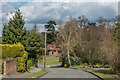
Blackstone Hill
c.1960s cul-de-sac built in the grounds of a large Victorian house named Blackstones.
Image: © Ian Capper
Taken: 12 Apr 2021
0.10 miles
5
The Chase
A road by the name of Chart Road is shown here on maps dating back to the late 19th century, and the route itself is probably older, being part of the network of paths that led from what is now Shaws Corner to Cockshot Hill (see Image for example).
However, development for housing did not start until the 1930s (the house on the right was built in 1932), and it seems that the name The Chase was introduced around that time, presumably as a marketing ploy
Image: © Ian Capper
Taken: 25 Apr 2011
0.11 miles
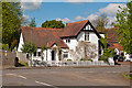
6
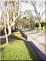
Ringley Park Avenue, Reigate
Looking North West
Image: © Rib
Taken: 21 Jan 2006
0.11 miles
7
Ringley Park Avenue
Residential road dropping down from High Trees Road on the Greensand ridge between Reigate and Redhill.
Image: © Ian Capper
Taken: 19 Apr 2021
0.11 miles
8
The Chase
A road marked on 19th and early 20th Century maps as Chart Road, but with no development, part of a line of paths and roads connecting Cockshot Hill and Shaws Corner. The current name first appears on the 1935 1:2,500 map, along with a few houses, including no 25, seen here. In the distance is St Paul's United Reformed Church.
Image: © Ian Capper
Taken: 12 Apr 2021
0.12 miles
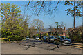
9
High Trees Road, Redhill Surrey
A private road viewed from the junction with Ringley Park Avenue
Image: © Richard Rogerson
Taken: 9 Aug 2009
0.14 miles
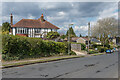
10
Ringley Park Avenue
House in Ringley Park Avenue opposite its junction with The Chase (in the foreground). Old maps suggest it was originally an outbuilding of Oak Lodge, a large house in Blanford Road dating from 1897.
The footpath on the left runs behind the rear gardens of Blanford Road and Waterlow Road and is part of an old route that connected Cockshot Hill with Shaws Corner, now variously footpaths and roads, including The Chase (see also Image, Image,Image,Image, Image and Image).
Image: © Ian Capper
Taken: 12 May 2012
0.14 miles