IMAGES TAKEN NEAR TO
Blackborough Road, REIGATE, RH2 7DF
Introduction
This page details the photographs taken nearby to Blackborough Road, RH2 7DF by members of the Geograph project.
The Geograph project started in 2005 with the aim of publishing, organising and preserving representative images for every square kilometre of Great Britain, Ireland and the Isle of Man.

There are currently over 7.5m images from over14,400 individuals and you can help contribute to the project by visiting https://www.geograph.org.uk
Image Map
Images are licensed for reuse under creativecommons.org/licenses/by-sa/2.0
Notes
- Clicking on the map will re-center to the selected point.
- The higher the marker number, the further away the image location is from the centre of the postcode.
Image Listing (103 Images Found)
Images are licensed for reuse under creativecommons.org/licenses/by-sa/2.0
Image
Details
Distance
1
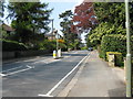
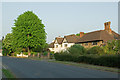
Reigate: Blackborough Road
Looking west. This road is part of the B2034.
Image: © Dr Neil Clifton
Taken: 18 Apr 2011
0.01 miles
2
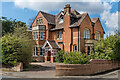
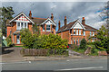
131 Blackborough Road
Large house in Blackborough Road dating from around the turn of the 19th/20th Centuries.
Image: © Ian Capper
Taken: 12 Apr 2021
0.06 miles
3
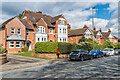
133 Blackborough Road
Large house in Blackborough Road dating from around the turn of the 19th/20th Centuries, extended since. Beyonnd are nos 135 and 137, of a similar age.
Image: © Ian Capper
Taken: 12 Apr 2021
0.07 miles
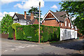
4
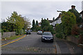
The Chase
A road marked on 19th and early 20th Century maps as Chart Road, but with no development, part of a line of paths and roads connecting Cockshot Hill and Shaws Corner. The current name first appears on the 1935 1:2,500 map, along with a few houses, including no 9, the nearest of the houses seen here. The further ones are not marked and so would seem to be slightly later.
Image: © Ian Capper
Taken: 12 Apr 2021
0.08 miles
5
The Chase
A road by the name of Chart Road is shown here on maps dating back to the late 19th century, and the route itself is probably older, being part of the network of paths that led from what is now Shaws Corner to Cockshot Hill (see Image for example).
However, development for housing did not start until the 1930s (the house on the right was built in 1932), and it seems that the name The Chase was introduced around that time, presumably as a marketing ploy
Image: © Ian Capper
Taken: 25 Apr 2011
0.08 miles
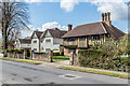
6
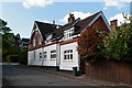
135 & 137 Blackborough Road
Pair of houses in Blackborough Road dating from around the turn of the 19th/20th Centuries. No 135, on the left, has the name Horsted House on the gate.
Image: © Ian Capper
Taken: 12 Apr 2021
0.08 miles
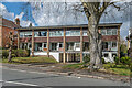
7
Ringley Park Avenue
Locally listed building in Ringley Park Avenue, dating from the late 19th century, built as the coachhouse and gardener's cottage for Parkwater, a large house whose chimney can be seen in the background (see Image).
Image: © Ian Capper
Taken: 12 May 2012
0.09 miles
8
Millway
The road name refers to Blackborough Mill, whose site was at the top end of this close. The mill, a post mill, was built around 1736, but had fallen into disuse by 1900 and was demolished in 1936.
Millway first appears on maps in the early 20th century.
Image: © Ian Capper
Taken: 9 Oct 2011
0.10 miles
9
Ringley Park Avenue
Seen here at its junction with Blanford Road. The house on the left, Parkwater, was built in 1896 and is one of a number of large properties in Blanford Road dating from the turn of that century. It was designed by local architect G Morrison. On its right is the associated coachhouse and gardener's cottage (see Image for closer view). Both buildings are locally listed.
Image: © Ian Capper
Taken: 12 May 2012
0.10 miles
10
Roquebrune
Block of 7 maisonettes at 139 Blackborough Road marked on the 1962 1:1,250 map, suggesting a build date in the c.1950s.
Image: © Ian Capper
Taken: 12 Apr 2021
0.10 miles