IMAGES TAKEN NEAR TO
Castlefield Road, REIGATE, RH2 2TS
Introduction
This page details the photographs taken nearby to Castlefield Road, RH2 2TS by members of the Geograph project.
The Geograph project started in 2005 with the aim of publishing, organising and preserving representative images for every square kilometre of Great Britain, Ireland and the Isle of Man.

There are currently over 7.5m images from over14,400 individuals and you can help contribute to the project by visiting https://www.geograph.org.uk
Image Map
Images are licensed for reuse under creativecommons.org/licenses/by-sa/2.0
Notes
- Clicking on the map will re-center to the selected point.
- The higher the marker number, the further away the image location is from the centre of the postcode.
Image Listing (830 Images Found)
Images are licensed for reuse under creativecommons.org/licenses/by-sa/2.0
Image
Details
Distance
1
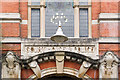
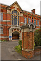
Doorway, Reigate Town Hall
Close up of one of the two original entrances to the building (see Image). This was the northern entrance (beyond the flags in the linked photo), giving access to what was once the police station and court house. For a photo of the other entrance, see Image For a view of the window above the door, from inside the building, see Image
Image: © Ian Capper
Taken: 11 Sep 2010
0.01 miles
2
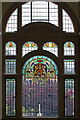
Window, Reigate Town Hall
This is the window above the original Court House and Police Station entrance to the building, viewed from inside the building. See Image for an exterior view of the entrance and Image for a close up of the royal coat of arms depicted in the window.
Image: © Ian Capper
Taken: 11 Sep 2010
0.01 miles
3
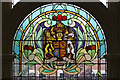
Royal Coat of Arms, Reigate Town Hall
Close up of the royal coat of arms in the window in Image
Image: © Ian Capper
Taken: 11 Sep 2010
0.01 miles
4
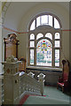
Main Staircase, Reigate Town Hall
The main staircase of Reigate Town Hall, formerly known as the Councillors' staircase. The balustrades are of Sicilian marble. For close up of the window, see Image The chairs are the original Mayor's Chair and Magistrate's Chair, supplied by the firm of Heal and Son when the building was opened in 1901. The memorial is to those who lost their lives in the Boer War and First and Second World Wars.
Image: © Ian Capper
Taken: 11 Sep 2010
0.01 miles
5
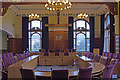
New Council Chamber, Reigate Town Hall
Converted from the previous Court Room, this is now the main chamber for Reigate and Banstead Borough Council. For close up of the coat of arms, see Image
Image: © Ian Capper
Taken: 11 Sep 2010
0.01 miles
6
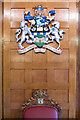
Reigate and Banstead Borough Council Coat of Arms, Reigate Town Hall
Close up of the coat of arms in the New Council Chamber (see Image). Compare the coat of arms of the original Borough of Reigate (see Image), the area of which was expanded following local government reorganisation in 1974. Although based around the original arms (and its subsequent successor, a new set having been granted in 1951), including retention of the original motto, it had components added representing the new areas added to the Borough, namely Banstead to the north and Sidlow, Salfords and Horley to the south. See http://www.ngw.nl/int/gbr/r/reigateb.htm for full description.
Note the arms of the original Borough in the Mayor's Chair, the top of which can be seen at the foot of the photo.
Image: © Ian Capper
Taken: 11 Sep 2010
0.01 miles
7
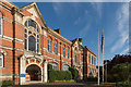
Reigate Town Hall
The offices of Reigate and Banstead Borough Council in Castlefield Road, dating from 1901. The building was designed by the architects Hugh Macintosh and Reginald Newman.
It was originally known as the Municipal Buildings, housing the Town Hall (which was in the nearest section of the building in this photo), the police station and court house (at the far end) and fire station (off the left of this photo - see Image). The police station is now in Reigate Road (see Image), having first moved to Cherchefelle (see Image) then, the courts are now in Hatchlands Road (see Image) and the fire station in Croydon Road (see Image), leaving the local council, now expanded from the original Borough of Reigate, as the sole occupant since 1974.
The building is grade II listed - see www.historicengland.org.uk/listing/the-list/list-entry/1260489.
Image: © Ian Capper
Taken: 3 Aug 2014
0.01 miles
8
Reigate Town Hall
The offices of Reigate and Banstead Borough Council in Castlefield Road, dating from 1901. The building was designed by the architects Hugh Macintosh and Reginald Newman.
The building is grade II listed - for listing particulars see www.historicengland.org.uk/listing/the-list/list-entry/1260489.
Image: © Ian Capper
Taken: 14 Dec 2013
0.01 miles
9
Reigate Town Hall
One of the entrances to Reigate Town Hall, the offices of Reigate and Banstead Borough Council in Castlefield Road, dating from 1901. The building was designed by the architects Hugh Macintosh and Reginald Newman.
For photo of the whole building, see Image
Grade II listed - for listing particulars see www.historicengland.org.uk/listing/the-list/list-entry/1260489.
Image: © Ian Capper
Taken: 5 Jul 2009
0.01 miles
10
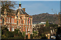
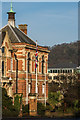
Reigate Town Hall
The offices of Reigate and Banstead Borough Council in Castlefield Road, dating from 1901. The building was designed by the architects Hugh Macintosh and Reginald Newman.
The building is grade II listed - for listing particulars see www.historicengland.org.uk/listing/the-list/list-entry/1260489.
In the background are the North Downs between Colley Hill and Reigate Hill.
Image: © Ian Capper
Taken: 14 Dec 2013
0.01 miles